IMAGES TAKEN NEAR TO
Greyfriars Road, CARDIFF, CF10 3AD
Introduction
This page details the photographs taken nearby to Greyfriars Road, CF10 3AD by members of the Geograph project.
The Geograph project started in 2005 with the aim of publishing, organising and preserving representative images for every square kilometre of Great Britain, Ireland and the Isle of Man.

There are currently over 7.5m images from over14,400 individuals and you can help contribute to the project by visiting https://www.geograph.org.uk
Image Map
Images are licensed for reuse under creativecommons.org/licenses/by-sa/2.0
Notes
- Clicking on the map will re-center to the selected point.
- The higher the marker number, the further away the image location is from the centre of the postcode.
Image Listing (898 Images Found)
Images are licensed for reuse under creativecommons.org/licenses/by-sa/2.0
Image
Details
Distance
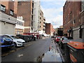
1
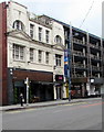
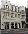
Barley & Rye, Cardiff
Bier Bar and Kitchen at 2 Greyfriars Road. https://www.geograph.org.uk/photo/5856322 to the name sign on the left.
Image: © Jaggery
Taken: 8 Jun 2017
0.01 miles
2
Glam nightclub, Cardiff
On the south side of Greyfriars Road.
Image: © Jaggery
Taken: 8 Jun 2017
0.01 miles
3
Oceana nightclub in Cardiff
Viewed across Greyfriars Road.
Image: © Jaggery
Taken: 20 Oct 2013
0.01 miles
4
Barley & Rye name sign, Greyfriars Road, Cardiff
Hanging from a wall bracket on the left here. https://www.geograph.org.uk/photo/5503367
Image: © Jaggery
Taken: 21 Sep 2017
0.01 miles
5
Fat Cat and Glam in Cardiff
Viewed across Greyfriars Road. Fat Cat cafe bar is on the left. Glam nightclub is on the right.
Image: © Jaggery
Taken: 20 Oct 2013
0.01 miles
6
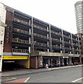
Welcome to Greyfriars Car Park, Cardiff
The multi-storey car park entrance is in Greyfriars Road. Capital Tower http://www.geograph.org.uk/photo/1669238 is in the background.
Image: © Jaggery
Taken: 20 Oct 2013
0.01 miles
7
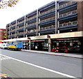
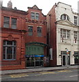
The Crockerton, Greyfriars Road, Cardiff
The Wetherspoon pub is under Greyfriars Car Park. The Wetherspoon website records that until 1887, the area around this pub had been known for centuries as Crockerton or Crockherbtown. It is likely that it got its unusual name from the pot (or crock) herbs cultivated by the monks of Greyfriars. Today, nearby narrow Crockherbtown Lane is almost the only reminder of this ancient area of Cardiff.
Image: © Jaggery
Taken: 22 Sep 2017
0.01 miles
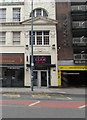
8
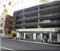
Yates bar below an NCP car park, Greyfriars Road, Cardiff
Viewed in September 2017. A May 2016 Google Earth Street View shows the Three Rivers pub here.
Image: © Jaggery
Taken: 21 Sep 2017
0.01 miles
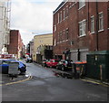
9
Wheelie bins, cars and puddles, Crockherbtown Lane, Cardiff city centre
This ancient part of Cardiff was known for centuries as Crockerton or Crockherbtown. It is likely that it got its unusual name from the pot (or crock) herbs cultivated by the monks of Greyfriars.
Image: © Jaggery
Taken: 21 Sep 2017
0.02 miles
10
East along Crockerbtown Lane towards Park Place, Cardiff
The dark green cabinet on the right is a Western Power Distribution electricity substation. https://www.geograph.org.uk/photo/5856413
Image: © Jaggery
Taken: 21 Sep 2017
0.02 miles