IMAGES TAKEN NEAR TO
Churchill Way, CARDIFF, CF10 2DY
Introduction
This page details the photographs taken nearby to Churchill Way, CF10 2DY by members of the Geograph project.
The Geograph project started in 2005 with the aim of publishing, organising and preserving representative images for every square kilometre of Great Britain, Ireland and the Isle of Man.

There are currently over 7.5m images from over14,400 individuals and you can help contribute to the project by visiting https://www.geograph.org.uk
Image Map
Images are licensed for reuse under creativecommons.org/licenses/by-sa/2.0
Notes
- Clicking on the map will re-center to the selected point.
- The higher the marker number, the further away the image location is from the centre of the postcode.
Image Listing (653 Images Found)
Images are licensed for reuse under creativecommons.org/licenses/by-sa/2.0
Image
Details
Distance
1
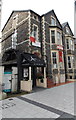
Amici, Cardiff
The national flag of Italy is above the entrance
to Amici Italian bar and ristorante at 24 Churchill Way.
Image: © Jaggery
Taken: 20 Oct 2013
0.00 miles
3
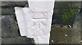
Ordnance Survey Cut Mark
This OS cut mark can be found on the east face of No18 Churchill Way. It marks a point 10.854m above mean sea level.
Image: © Adrian Dust
Taken: 1 Oct 2017
0.02 miles
4
Perfections Beauty Therapy, Cardiff
Perfections on the left is in Churchill Way, facing North Edward Street. http://www.geograph.org.uk/photo/3724465
Image: © Jaggery
Taken: 20 Oct 2013
0.02 miles
5
Naroush, Cardiff
The Naroush banner stretches along the balcony above the Churchill Way
entrance to the Lebanese charcoal grill and restaurant.
Image: © Jaggery
Taken: 20 Oct 2013
0.02 miles
6
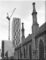
Former School Room, Cardiff
Facing Wesley Lane, this is the east side of the former School Room to the Ebeneser Chapel. "1871, by W D Blessley" http://ishare.cardiff.gov.uk/Projects/Cadw/CardiffListedBuildings/13669.pdf . A tower block rises in the background.
Image: © Derek Harper
Taken: 16 Jun 2018
0.02 miles
7
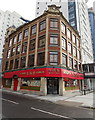
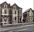
Golden Corner, Cardiff
Oriental restaurant on the corner of Churchill Way and North Edward Street.
The building is Limerick House. http://www.geograph.org.uk/photo/3724438 There are offices on the upper floors.
Image: © Jaggery
Taken: 20 Oct 2013
0.02 miles
8
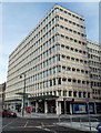
Jessops Cardiff
Located on the ground floor on the corner of North Edward Street, Jessops is at 4 Churchill House, Churchill Way. Jessops is a phoenix from the ashes. Two days after Jessops Group Limited went into administration in January 2013, it was announced that all 187 stores would close, with a loss of more than a thousand jobs. However, at the end of January 2013 the Jessops brand and various assets were acquired by entrepreneur Peter Jones. Since then, several dozen Jessops stores have reopened.
Image: © Jaggery
Taken: 20 Oct 2013
0.03 miles
9
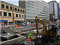
Construction work to uncover the dock feeder canal on Churchill Way
Work continues to redevelop Churchill Way in Cardiff City Centre, including uncovering the Dock Feeder Canal, which was culverted many decades previously.
Image: © Gareth James
Taken: 23 Oct 2023
0.03 miles
10
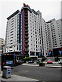
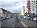
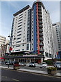
Landmark Place, Cardiff city centre
51 metre (167 feet) high apartment building viewed across Churchill Way.
There are about 280 apartments and some business premises in Landmark Place.
Image: © Jaggery
Taken: 10 Jun 2017
0.03 miles