IMAGES TAKEN NEAR TO
Clover Field, HAVERHILL, CB9 9QE
Introduction
This page details the photographs taken nearby to Clover Field, CB9 9QE by members of the Geograph project.
The Geograph project started in 2005 with the aim of publishing, organising and preserving representative images for every square kilometre of Great Britain, Ireland and the Isle of Man.

There are currently over 7.5m images from over14,400 individuals and you can help contribute to the project by visiting https://www.geograph.org.uk
Image Map
Images are licensed for reuse under creativecommons.org/licenses/by-sa/2.0
Notes
- Clicking on the map will re-center to the selected point.
- The higher the marker number, the further away the image location is from the centre of the postcode.
Image Listing (5 Images Found)
Images are licensed for reuse under creativecommons.org/licenses/by-sa/2.0
Image
Details
Distance
1
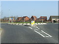
Roundabout
Roundabout at the end of Bergamot Road Haverhill, Suffolk.
Image: © Keith Evans
Taken: 15 Mar 2012
0.07 miles
2
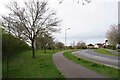
A Bend in Chivers Road
A greensward in the outskirts of Haverhill.
Image: © Glyn Baker
Taken: 8 Apr 2021
0.18 miles
3
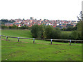
The town of Haverhill, Suffolk
View from Chivers Road with small wetland in foreground, rooftops of the town in the middle distance and water tower in the far distance Image
Image: © Rodney Burton
Taken: 8 Oct 2005
0.21 miles
4
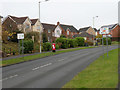
Chivers Way
Housing in western Haverhill, late 1990s. The post box is CB9 59. The road signs say "MIND THAT CHILD" and "SLOW DOWN" in children's art style, but are so difficult to read they are probably a dangerous distraction to drivers rather than a safety enhancement.
Image: © Keith Edkins
Taken: 15 Nov 2017
0.24 miles
5
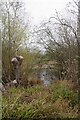
Balancing Pond by Chivers Road
There was a gaggle of male Mallards on this small pond.
Image: © Glyn Baker
Taken: 8 Apr 2021
0.24 miles