IMAGES TAKEN NEAR TO
Greenfields Way, HAVERHILL, CB9 8NJ
Introduction
This page details the photographs taken nearby to Greenfields Way, CB9 8NJ by members of the Geograph project.
The Geograph project started in 2005 with the aim of publishing, organising and preserving representative images for every square kilometre of Great Britain, Ireland and the Isle of Man.

There are currently over 7.5m images from over14,400 individuals and you can help contribute to the project by visiting https://www.geograph.org.uk
Image Map
Images are licensed for reuse under creativecommons.org/licenses/by-sa/2.0
Notes
- Clicking on the map will re-center to the selected point.
- The higher the marker number, the further away the image location is from the centre of the postcode.
Image Listing (13 Images Found)
Images are licensed for reuse under creativecommons.org/licenses/by-sa/2.0
Image
Details
Distance
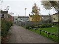
1
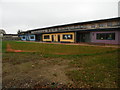
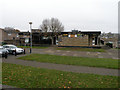
Clements Community Primary School
Clements School moved into these buildings in 2011, and became an Academy on 1st May 2017 through the Samuel Ward Academy Trust. It teaches about 260 children, including nursery classes.
Image: © Keith Edkins
Taken: 15 Nov 2017
0.01 miles
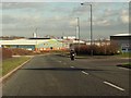
2
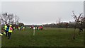
Puddlebrook Playing Fields
Home to Haverhill's recently established parkrun: http://www.parkrun.org.uk/haverhill/
Image: © Stuart Shepherd
Taken: 24 Mar 2018
0.10 miles
3
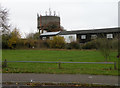
Burton End Water Tower
Viewed from Cleves Road. I understand this tower is no longer used for water supplies and is just somewhere convenient to stick aerials.
Image: © Keith Edkins
Taken: 15 Nov 2017
0.13 miles
4
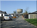
Water Tower
Water among the houses at Haverhill, Suffolk.
Image: © Keith Evans
Taken: 15 Mar 2012
0.13 miles
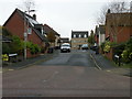
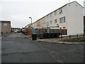
6
Fritton Court, Clements
Part of a high density 1960s GLC "overspill" development. Housing in the area is now run by Havebury Housing Partnership.
Image: © Keith Edkins
Taken: 15 Nov 2017
0.14 miles
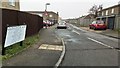
7
Cramswell Close
Built at the same time as the Henry VIII themed streets, but this name appears to be entirely invented
Image: © Keith Edkins
Taken: 15 Nov 2017
0.16 miles
9
The Suffolk Punch
Pub in the Clements estate.
Image: © Keith Edkins
Taken: 15 Nov 2017
0.20 miles
10
Harewood Terrace, Clements
Part of a high density 1960s GLC "overspill" development. Housing in the area is now run by Havebury Housing Partnership.
Image: © Keith Edkins
Taken: 15 Nov 2017
0.21 miles