IMAGES TAKEN NEAR TO
High Street, HAVERHILL, CB9 8AN
Introduction
This page details the photographs taken nearby to High Street, CB9 8AN by members of the Geograph project.
The Geograph project started in 2005 with the aim of publishing, organising and preserving representative images for every square kilometre of Great Britain, Ireland and the Isle of Man.

There are currently over 7.5m images from over14,400 individuals and you can help contribute to the project by visiting https://www.geograph.org.uk
Image Map
Images are licensed for reuse under creativecommons.org/licenses/by-sa/2.0
Notes
- Clicking on the map will re-center to the selected point.
- The higher the marker number, the further away the image location is from the centre of the postcode.
Image Listing (75 Images Found)
Images are licensed for reuse under creativecommons.org/licenses/by-sa/2.0
Image
Details
Distance
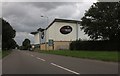
1
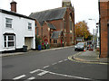
United Reformed Church, Hamlet Road
Originally Congregational Church, 1884 by Charles Bell of London. Grade II* listed. The post box is CB9 1.
Image: © Keith Edkins
Taken: 15 Nov 2017
0.05 miles
4
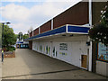
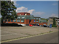
Former Co-op, Haverhill
With a banner for the Haverhill Town Centre Masterplan. It will soon open as a Poundstretcher store.
Image: © Hugh Venables
Taken: 20 Sep 2015
0.11 miles
5
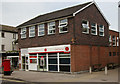
Haverhill Post Office
Good example of a small town post office still open! Mid-1960s.
Image: © Jim Osley
Taken: 17 May 2012
0.12 miles
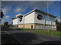
9
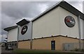
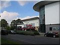
Cineworld on Ehringshausen Way, Haverhill
Image: © David Howard
Taken: 23 Aug 2020
0.13 miles