
IMAGES TAKEN NEAR TO
High Street, HAVERHILL, CB9 8AA
Introduction
This page details the photographs taken nearby to High Street, CB9 8AA by members of the Geograph project.
The Geograph project started in 2005 with the aim of publishing, organising and preserving representative images for every square kilometre of Great Britain, Ireland and the Isle of Man.

There are currently over 7.5m images from over14,400 individuals and you can help contribute to the project by visiting https://www.geograph.org.uk
Image Map
Images are licensed for reuse under creativecommons.org/licenses/by-sa/2.0
Notes
- Clicking on the map will re-center to the selected point.
- The higher the marker number, the further away the image location is from the centre of the postcode.
Image Listing (136 Images Found)
Images are licensed for reuse under creativecommons.org/licenses/by-sa/2.0
Image
Details
Distance
1
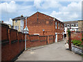
Back of High Street shop, from Quaker's Lane, Haverhill
An unlisted building dated 1839 on the front, which otherwise has a modern shop front on the ground floor. It resembles a chapel or hall. The Quakers' meeting house, now two houses, is off to the near right, so it was not that. A local history site revealed the answer: it was the Market Hill Chapel built to house a break away faction of the Independent Congregational Chapel after a disagreement about finances in 1836. They moved to a new chapel about 1890.
Image: © Robin Webster
Taken: 3 Jun 2018
0.01 miles
2
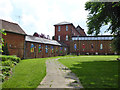
Corner of churchyard and old factory buildings, Haverhill
The former clothing factory buildings are Victorian, grade II listed. It is surprising that a large factory could be set up right next to the town centre churchyard, Haverhill must have been very different in those days.
Image: © Robin Webster
Taken: 3 Jun 2018
0.03 miles
3
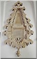
Haverhill - John Ward of Massachusetts
Rev.John Ward helped found Haverhill in Massachusetts, USA. The town was named after the place of his birth in Suffolk.
Image: © Ashley Dace
Taken: 22 Jul 2013
0.03 miles
4
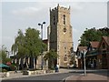
St. Mary: the parish church of Haverhill
It is, mainly, a perpendicular church although it was extensively restored by the Victorians. The church suffered from the town's great fire in 1665.
Image: © Robert Edwards
Taken: 24 Aug 2009
0.03 miles
5
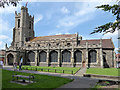
Haverhill church
St. Mary's is a grade II*(star) listed building, 13th/14th century in origin with much later extension and refurbishment.
Image: © Robin Webster
Taken: 3 Jun 2018
0.03 miles
7
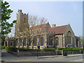
Haverhill St Mary?s church
Haverhill’s splendid and richly endowed church suffered a serious fire in 1665 just a year before the Great Fire of London, and very little remained except the 14th c. nave walls and tower. The three pinnacles are carved grotesque figures. At the fourth corner is the stair turret, which continues above the embattled parapet. What we see today is a typical town church rebuilt about the same time as St Paul’s Cathedral. The font is the original from before the fire. The font cover is the work of Frederick Gibberd, famed for being the designer of Liverpool’s great Catholic Cathedral. Unfortunately, the church is usually kept locked. There is little of historical or architectural interest to see here apart from the aforementioned. The interest lies in the rise of Haverhill as a town, and its trials and tribulations through the centuries, to become Suffolk’s fifth largest town today.
Image: © Adrian S Pye
Taken: 29 Apr 2007
0.03 miles
9
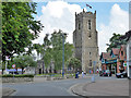
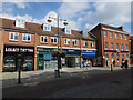
Haverhill church
St. Mary's is a grade II*(star) listed building, 13th/14th century in origin with much later extension and refurbishment.
Image: © Robin Webster
Taken: 3 Jun 2018
0.04 miles
10

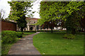
Former Chauntry Clothing Mills, Haverhill
Now offices and the like. A view through the High Street entrance. The older buildings on the site are grade II listed, from the mid 19th century.
Image: © Robin Webster
Taken: 3 Jun 2018
0.04 miles