IMAGES TAKEN NEAR TO
Woods Close, HAVERHILL, CB9 7ZH
Introduction
This page details the photographs taken nearby to Woods Close, CB9 7ZH by members of the Geograph project.
The Geograph project started in 2005 with the aim of publishing, organising and preserving representative images for every square kilometre of Great Britain, Ireland and the Isle of Man.

There are currently over 7.5m images from over14,400 individuals and you can help contribute to the project by visiting https://www.geograph.org.uk
Image Map
Images are licensed for reuse under creativecommons.org/licenses/by-sa/2.0
Notes
- Clicking on the map will re-center to the selected point.
- The higher the marker number, the further away the image location is from the centre of the postcode.
Image Listing (34 Images Found)
Images are licensed for reuse under creativecommons.org/licenses/by-sa/2.0
Image
Details
Distance
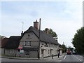
6
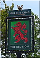
Sign for the Red Lion, Sturmer
See Image] for context.
Image: © JThomas
Taken: 31 Aug 2019
0.05 miles
8
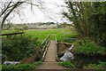
Stour Brook Confluence
A small stream joins with Stour Brook.
Image: © Glyn Baker
Taken: 20 Apr 2021
0.07 miles
10
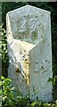
Old Milestone, A1017, Rowley Hill, Sturmer
The milestone is located 60m south east of the junction with Church Croft, on the verge by the pedestrian crossing on the south side of road. Parish of Sturmer (Braintree District). Cast iron post, erected by the Halstead (Division of Essex First District) turnpike trust in the 19th century. Next to milestone: EX_COHV27A Image
Inscription reads:-
: HAVERHILL / 1 : : COLCHESTER / 27 / Sturmer : : HALSTED / 14 :
Grade II listed together with adjacent milestone, List Entry Number: 1470460
https://historicengland.org.uk/listing/the-list/list-entry/1470460
Milestone Society National ID: EX_COHV27
Image: © Robin Hall
Taken: Unknown
0.11 miles