IMAGES TAKEN NEAR TO
Roost End, HAVERHILL, CB9 7XW
Introduction
This page details the photographs taken nearby to Roost End, CB9 7XW by members of the Geograph project.
The Geograph project started in 2005 with the aim of publishing, organising and preserving representative images for every square kilometre of Great Britain, Ireland and the Isle of Man.

There are currently over 7.5m images from over14,400 individuals and you can help contribute to the project by visiting https://www.geograph.org.uk
Image Map
Images are licensed for reuse under creativecommons.org/licenses/by-sa/2.0
Notes
- Clicking on the map will re-center to the selected point.
- The higher the marker number, the further away the image location is from the centre of the postcode.
Image Listing (19 Images Found)
Images are licensed for reuse under creativecommons.org/licenses/by-sa/2.0
Image
Details
Distance
1
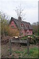
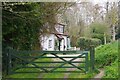
Linnetts Lane
The cottage is featured on the Image
Image: © Glyn Baker
Taken: 20 Apr 2021
0.04 miles
2
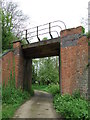
Old Railway Bridge
Old railway bridge of the former Marks Tey to Cambridge line at Sturmer, Essex.
Image: © Keith Evans
Taken: 10 May 2012
0.05 miles
3
The Sturmer Steps Heritage Trail
On Image looking towards the old railway bridge that once carried the Stour Valley Railway https://en.wikipedia.org/wiki/Stour_Valley_Railway . For more info on the trail see https://www.kindid.co.uk/sturmer/steps.pdf
Image: © Glyn Baker
Taken: 20 Apr 2021
0.05 miles
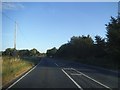
4
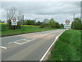
Entering Sturmer
Entering Sturmer, Essex on the A.1017.
Image: © Keith Evans
Taken: 10 May 2012
0.06 miles
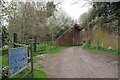
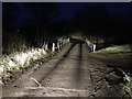
5
Linnets Lane at Mere Cottage
Looking towards Roost End.
Image: © Glyn Baker
Taken: 20 Apr 2021
0.09 miles
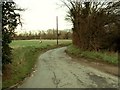
7
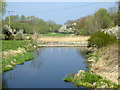
Border Ford at Sturmer
Ains Ford on the River Stour marks the county boundary between Essex and Suffolk. The ford is found just off the A1017 on the road leading to Wixoe.
Image: © John Walton
Taken: 22 Feb 2013
0.18 miles
9
Ains Ford
A crossing of the River Stour, with no fording required today, the river going under the road. Essex on the left bank, Suffolk on the right.
Image: © Robin Webster
Taken: 8 Apr 2017
0.19 miles
10
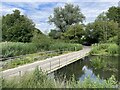
Ains Ford at Sturmer
This is a much better image of this irish bridge ford at Sturmer. My previous attempt can be seen at:
https://www.geograph.org.uk/photo/3343240
Image: © John Walton
Taken: 24 Jun 2023
0.19 miles