IMAGES TAKEN NEAR TO
Kedington Road, HAVERHILL, CB9 7XR
Introduction
This page details the photographs taken nearby to Kedington Road, CB9 7XR by members of the Geograph project.
The Geograph project started in 2005 with the aim of publishing, organising and preserving representative images for every square kilometre of Great Britain, Ireland and the Isle of Man.

There are currently over 7.5m images from over14,400 individuals and you can help contribute to the project by visiting https://www.geograph.org.uk
Image Map
Images are licensed for reuse under creativecommons.org/licenses/by-sa/2.0
Notes
- Clicking on the map will re-center to the selected point.
- The higher the marker number, the further away the image location is from the centre of the postcode.
Image Listing (37 Images Found)
Images are licensed for reuse under creativecommons.org/licenses/by-sa/2.0
Image
Details
Distance
2
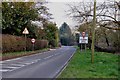
Sturmer railway station (site), Essex
Opened in 1865 by the Great Eastern Railway on the line from Marks Tey to Cambridge, this station closed in 1967.
View south east towards Stoke and Marks Tey. Only the nearest building is the original railway structure. The single track ran to the right of it, where the lawn now is. It is now a private residence.
For more information, see http://www.disused-stations.org.uk/s/sturmer/index.shtml
Image: © Nigel Thompson
Taken: 3 Sep 2020
0.07 miles
3
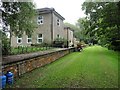
Former Railway Station
The former railway station at Sturmer, Essex.
Image: © Keith Evans
Taken: 4 Oct 2012
0.07 miles
4
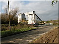
Hanson Haverhill Concrete
This depot supplies ready-mixed concrete
Image: © Keith Edkins
Taken: 22 Nov 2017
0.07 miles
5
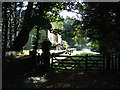
Former Sturmer Station
First stop out of Haverhill on the Old Stour Valley Railway https://en.wikipedia.org/wiki/Stour_Valley_Railway
Image: © Glyn Baker
Taken: 20 Apr 2021
0.07 miles
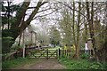
6
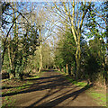
Sturmer: once a railway
This path follows the trackbed of the Cambridge-Colchester Stour Valley railway line. The Shelford-Sudbury section of the railway closed in 1967.
Image: © John Sutton
Taken: 11 Feb 2022
0.07 miles
7
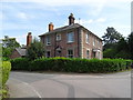
The Old Station House, Sturmer
The railway closed in 1967.
Image: © JThomas
Taken: 31 Aug 2019
0.09 miles
8
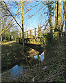
Sturmer: former Great Eastern Railway bridge
This bridge over Stour Brook, a tributary of the River Stour, once carried the Cambridge-Colchester Stour Valley railway line. The trackbed is now a path. The Shelford-Sudbury section of the railway closed in 1967.
Image: © John Sutton
Taken: 11 Feb 2022
0.10 miles
9
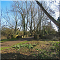
Sturmer: snowdrops and former railway bridge
This bridge once carried the Cambridge-Colchester Stour Valley railway line. The trackbed is now a path. The Shelford-Sudbury section of the railway closed in 1967.
Image: © John Sutton
Taken: 11 Feb 2022
0.10 miles
10
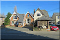
Sturmer Village Hall
Victorian red brick, photographed from the other side of the A1017 on a bright February morning.
Image: © John Sutton
Taken: 11 Feb 2022
0.10 miles