IMAGES TAKEN NEAR TO
Reydon Close, HAVERHILL, CB9 7WG
Introduction
This page details the photographs taken nearby to Reydon Close, CB9 7WG by members of the Geograph project.
The Geograph project started in 2005 with the aim of publishing, organising and preserving representative images for every square kilometre of Great Britain, Ireland and the Isle of Man.

There are currently over 7.5m images from over14,400 individuals and you can help contribute to the project by visiting https://www.geograph.org.uk
Image Map
Images are licensed for reuse under creativecommons.org/licenses/by-sa/2.0
Notes
- Clicking on the map will re-center to the selected point.
- The higher the marker number, the further away the image location is from the centre of the postcode.
Image Listing (7 Images Found)
Images are licensed for reuse under creativecommons.org/licenses/by-sa/2.0
Image
Details
Distance
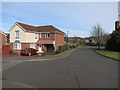
2

Langham Way, Haverhill
A fairly recent expansion of Haverhill, presumably the pavement will come later.
Image: © Hugh Venables
Taken: 2 Apr 2015
0.13 miles
3
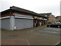
Shops in Apple Acre Road
Here we have "Your Favourites" take-away, Premier convenience store, off-licence and post office, and Domino's pizza
Image: © Keith Edkins
Taken: 15 Nov 2017
0.13 miles
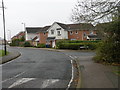
4

Apple Acre Road
Modern housing in north Haverhill, ca. 2006
Image: © Keith Edkins
Taken: 15 Nov 2017
0.17 miles
5
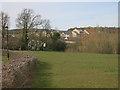
Hanchett End, Haverhill
With further expansion of Haverhill beyond.
Image: © Hugh Venables
Taken: 2 Apr 2015
0.19 miles

7
Apple Acre Road and Burnt House Close
They aren't afraid of long street names in Haverhill!
Image: © Keith Edkins
Taken: 15 Nov 2017
0.25 miles