IMAGES TAKEN NEAR TO
Haverhill Road, HAVERHILL, CB9 7UD
Introduction
This page details the photographs taken nearby to Haverhill Road, CB9 7UD by members of the Geograph project.
The Geograph project started in 2005 with the aim of publishing, organising and preserving representative images for every square kilometre of Great Britain, Ireland and the Isle of Man.

There are currently over 7.5m images from over14,400 individuals and you can help contribute to the project by visiting https://www.geograph.org.uk
Image Map
Images are licensed for reuse under creativecommons.org/licenses/by-sa/2.0
Notes
- Clicking on the map will re-center to the selected point.
- The higher the marker number, the further away the image location is from the centre of the postcode.
Image Listing (7 Images Found)
Images are licensed for reuse under creativecommons.org/licenses/by-sa/2.0
Image
Details
Distance
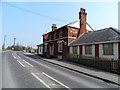
2
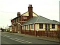
'The Fox' public house, on the A.143
Image: © Robert Edwards
Taken: 15 Jan 2007
0.07 miles
3
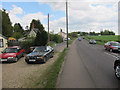
Haverhill Road leaving Haverhill
A143 to Bury St Edmunds.
Image: © Hugh Venables
Taken: 13 May 2012
0.12 miles
4
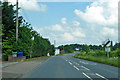
A143 leaves Haverhill
Heading towards Bury St Edmunds.
Image: © Robin Webster
Taken: 3 Jun 2018
0.13 miles
5
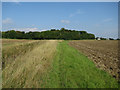
Great Wilsey development site
A primary school is planned for the area on the right.
Image: © Hugh Venables
Taken: 20 Sep 2015
0.22 miles

7
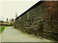
Old barn at Hill's Farm
This farm stands alongside the A.143
Image: © Robert Edwards
Taken: 15 Jan 2007
0.22 miles