IMAGES TAKEN NEAR TO
Camps Road, HAVERHILL, CB9 7AS
Introduction
This page details the photographs taken nearby to Camps Road, CB9 7AS by members of the Geograph project.
The Geograph project started in 2005 with the aim of publishing, organising and preserving representative images for every square kilometre of Great Britain, Ireland and the Isle of Man.

There are currently over 7.5m images from over14,400 individuals and you can help contribute to the project by visiting https://www.geograph.org.uk
Image Map
Images are licensed for reuse under creativecommons.org/licenses/by-sa/2.0
Notes
- Clicking on the map will re-center to the selected point.
- The higher the marker number, the further away the image location is from the centre of the postcode.
Image Listing (38 Images Found)
Images are licensed for reuse under creativecommons.org/licenses/by-sa/2.0
Image
Details
Distance
1
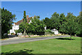
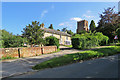
Helions Bumpstead: The Old Vicarage
This Grade II listed timber-framed house dates from the 16th century, with additions and alterations in succeeding centuries. The picture was taken from the green next to the crossroads in the centre of the village on a bright August morning.
Image: © John Sutton
Taken: 20 Aug 2020
0.11 miles
2
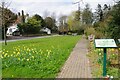
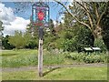
Helions Bumpstead Village Green
Daffs aplenty at this time of year.
Image: © Glyn Baker
Taken: 8 Apr 2021
0.11 miles
3
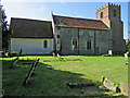
Helions Bumpstead: St Andrew - north side
The Grade II* listed parish church dates from the 13th century, with many later features, including 15th-century windows in the north wall of the nave and a brick tower built in 1812.
Image: © John Sutton
Taken: 20 Aug 2020
0.12 miles
4
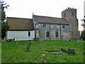
Helions Bumpstead church
St. Andrew's.
Image: © Robin Webster
Taken: 11 Jan 2015
0.12 miles
5
Helions Bumpstead: Upper House and the church tower
The church is mediaeval, but its brick tower dates from 1812.
Image: © John Sutton
Taken: 20 Aug 2020
0.12 miles
6
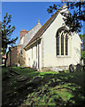
Helions Bumpstead: St Andrew - from the east
The churchyard is small, with a number of trees on the south side. The Grade II* listed parish church has features from various centuries, including a "C15 E window of three cinquefoiled lights with restored mullions and tracery under a two-centred head with drip mould".
Image: © John Sutton
Taken: 20 Aug 2020
0.12 miles
8
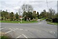
Helions Bumpstead
Looking from Sages End Road towards Image
Image: © Glyn Baker
Taken: 8 Apr 2021
0.13 miles
10

St Andrew's church, Helions Bumpstead
"Bumsteda" means a place where flax grows. Helions comes from the place in Brittany, Hellean associated with the Norman who was granted the land by William the Conqueror.
St Andrew's church dates from the C13. The tower however is C19.
Image: © Bikeboy
Taken: 4 May 2014
0.13 miles