IMAGES TAKEN NEAR TO
Helions Bumpstead, HAVERHILL, CB9 7AB
Introduction
This page details the photographs taken nearby to CB9 7AB by members of the Geograph project.
The Geograph project started in 2005 with the aim of publishing, organising and preserving representative images for every square kilometre of Great Britain, Ireland and the Isle of Man.

There are currently over 7.5m images from over14,400 individuals and you can help contribute to the project by visiting https://www.geograph.org.uk
Image Map
Images are licensed for reuse under creativecommons.org/licenses/by-sa/2.0
Notes
- Clicking on the map will re-center to the selected point.
- The higher the marker number, the further away the image location is from the centre of the postcode.
Image Listing (9 Images Found)
Images are licensed for reuse under creativecommons.org/licenses/by-sa/2.0
Image
Details
Distance
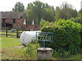
2
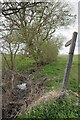
Footpath by a Stream in Wiggens Green
The footpath is the 898m long PROW 91_61
Image: © Glyn Baker
Taken: 8 Apr 2021
0.14 miles
4
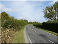
Bend in Copy Hill near Copy Farm
Towards Haverhill.
Image: © JThomas
Taken: 31 Aug 2019
0.16 miles
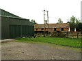
5
Broken down buildings at Copy Farm
The roof looks only slightly more worse for wear than it did in 2006. See http://www.geograph.org.uk/photo/240202
Image: © Bikeboy
Taken: 4 May 2014
0.16 miles
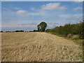
7
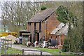
Tired Brick Barn at Copy Farm
This apparently nineteenth century barn has clearly seen better days.
Image: © Glyn Baker
Taken: 8 Apr 2021
0.17 miles
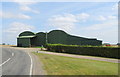
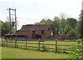
8
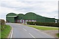
Green Barn at Copy Farm
A corrugated iron barn by the Haverhill Road
Image: © Glyn Baker
Taken: 8 Apr 2021
0.20 miles