IMAGES TAKEN NEAR TO
Strasbourg Square, HAVERHILL, CB9 0HR
Introduction
This page details the photographs taken nearby to Strasbourg Square, CB9 0HR by members of the Geograph project.
The Geograph project started in 2005 with the aim of publishing, organising and preserving representative images for every square kilometre of Great Britain, Ireland and the Isle of Man.

There are currently over 7.5m images from over14,400 individuals and you can help contribute to the project by visiting https://www.geograph.org.uk
Image Map
Images are licensed for reuse under creativecommons.org/licenses/by-sa/2.0
Notes
- Clicking on the map will re-center to the selected point.
- The higher the marker number, the further away the image location is from the centre of the postcode.
Image Listing (49 Images Found)
Images are licensed for reuse under creativecommons.org/licenses/by-sa/2.0
Image
Details
Distance
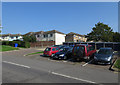
2
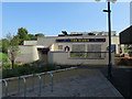
The Vixen
Closed pub on the Chalkstone Estate, Haverhill.
Image: © Hugh Venables
Taken: 20 Sep 2015
0.02 miles
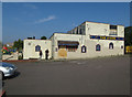
3
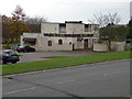
The (former) Vixen, Millfields Way
According to local CAMRA the pub closed in 2011. Plans have recently been approved for an apartment block and shops on the site.
Image: © Keith Edkins
Taken: 22 Nov 2017
0.02 miles
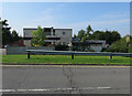
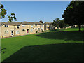
5
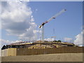
Cleves Place care home
Opened earlier in the year on the site of Chalkstone Middle School.
Image: © Hugh Venables
Taken: 20 Sep 2015
0.07 miles
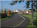
7
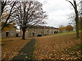
Elmdon Place, Haverhill
Terrace on a hill between Millfields Way and Chalkstone Way.
Image: © Keith Edkins
Taken: 22 Nov 2017
0.09 miles