IMAGES TAKEN NEAR TO
Queen Street, NEWMARKET, CB8 9QB
Introduction
This page details the photographs taken nearby to Queen Street, CB8 9QB by members of the Geograph project.
The Geograph project started in 2005 with the aim of publishing, organising and preserving representative images for every square kilometre of Great Britain, Ireland and the Isle of Man.

There are currently over 7.5m images from over14,400 individuals and you can help contribute to the project by visiting https://www.geograph.org.uk
Image Map
Images are licensed for reuse under creativecommons.org/licenses/by-sa/2.0
Notes
- Clicking on the map will re-center to the selected point.
- The higher the marker number, the further away the image location is from the centre of the postcode.
Image Listing (15 Images Found)
Images are licensed for reuse under creativecommons.org/licenses/by-sa/2.0
Image
Details
Distance
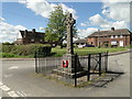
2
Cowlinge village sign, not far from the War Memorial
A detailed image can be seen here > http://www.geograph.org.uk/photo/4450521
Image: © Adrian S Pye
Taken: 27 Apr 2015
0.11 miles
3
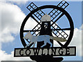
Cowlinge village sign (detail)
The sign depicts several of the rural crafts and businesses that Cowlinge has had over the centuries before. There is the ubiquitous windmill with its window in the shape of a coffin to remind us of the village undertaker. There is a wheel to remind us of the wheelwright and a fox depicting a Silver Fox Farm that used to be in the village. Also the whole sign sits on top of an anvil to remind us of the blacksmith.
http://www.geograph.org.uk/photo/4450519
Image: © Adrian S Pye
Taken: 27 Apr 2015
0.11 miles
4
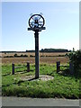
Cowling Village Sign
Village sign at Cowlinge, Suffolk.
Image: © Keith Evans
Taken: 31 Aug 2012
0.14 miles
6
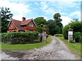
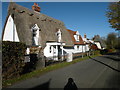
Lodge house to Branches Park
Branches Park was laid out Capability Brown in C18.
Image: © Bikeboy
Taken: 28 Jun 2014
0.15 miles
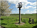
7
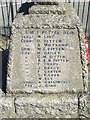
War Memorial Tablet
Tablet on the war memorial at Cowlinge, Suffolk. For other tablet and overall view see http://www.geograph.org.uk/photo/3107850 http://www.geograph.org.uk/photo/3107842
Image: © Keith Evans
Taken: 31 Aug 2012
0.16 miles
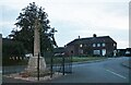
8
Cowlinge War Memorial
The memorial bears 30 names of men lost from the village in WW1. There were also two men and one woman lost in WW2 but not named on the memorial.
Image: © Adrian S Pye
Taken: 27 Apr 2015
0.16 miles
10
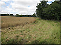
Permissive path
From Trotting Horse Lane just west of Lambfair Green to Bradley Road just west of Cowlinge.
Image: © Hugh Venables
Taken: 2 Aug 2009
0.16 miles