IMAGES TAKEN NEAR TO
Cowlinge, NEWMARKET, CB8 9JA
Introduction
This page details the photographs taken nearby to CB8 9JA by members of the Geograph project.
The Geograph project started in 2005 with the aim of publishing, organising and preserving representative images for every square kilometre of Great Britain, Ireland and the Isle of Man.

There are currently over 7.5m images from over14,400 individuals and you can help contribute to the project by visiting https://www.geograph.org.uk
Image Map
Images are licensed for reuse under creativecommons.org/licenses/by-sa/2.0
Notes
- Clicking on the map will re-center to the selected point.
- The higher the marker number, the further away the image location is from the centre of the postcode.
Image Listing (8 Images Found)
Images are licensed for reuse under creativecommons.org/licenses/by-sa/2.0
Image
Details
Distance
1
Cottages at Thrift Farm
The farm (behind the trees to the left) is in Suffolk, but the cottages are - just - in Cambridgeshire. The road is the county boundary for about 75 metres here.
Image: © John Sutton
Taken: 21 Sep 2023
0.05 miles
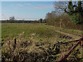
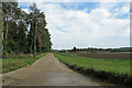
3
Track near Thrift Farm
This farm track leads westwards from Bradley Road, just south of Thrift Farm.
Image: © Bob Jones
Taken: 21 Feb 2015
0.07 miles
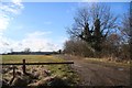
4
Track around Thrift Farm
Bases Wood in the background.
Image: © Hugh Venables
Taken: 6 Dec 2008
0.08 miles
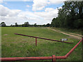
5

Stubble field
Looking towards Great Wood from close to Thrift Farm.
Image: © Hugh Venables
Taken: 6 Dec 2008
0.14 miles
6
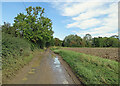
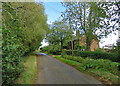
Puddles on Bradley Road
This narrow lane links Great Bradley and Cowlinge to Kirtling Green (ahead), just over the county boundary in Cambridgeshire. There had been a lot of rain in the two days before this end-of-summer picture was taken.
Image: © John Sutton
Taken: 21 Sep 2023
0.15 miles
7
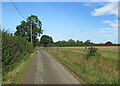
On the way to Kirtling
This narrow lane links Great Bradley and Cowlinge to Kirtling Green (ahead), just over the county boundary in Cambridgeshire.
Image: © John Sutton
Taken: 21 Sep 2023
0.22 miles
8
Concrete road to Banstead Farm
Banstead Farm on the sign at the entrance, but Banstead's Farm on OS maps.
Image: © John Sutton
Taken: 21 Sep 2023
0.22 miles