IMAGES TAKEN NEAR TO
Grosvenor Yard, NEWMARKET, CB8 9AW
Introduction
This page details the photographs taken nearby to Grosvenor Yard, CB8 9AW by members of the Geograph project.
The Geograph project started in 2005 with the aim of publishing, organising and preserving representative images for every square kilometre of Great Britain, Ireland and the Isle of Man.

There are currently over 7.5m images from over14,400 individuals and you can help contribute to the project by visiting https://www.geograph.org.uk
Image Map
Images are licensed for reuse under creativecommons.org/licenses/by-sa/2.0
Notes
- Clicking on the map will re-center to the selected point.
- The higher the marker number, the further away the image location is from the centre of the postcode.
Image Listing (133 Images Found)
Images are licensed for reuse under creativecommons.org/licenses/by-sa/2.0
Image
Details
Distance
1
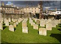
All Saints graveyard, Newmarket
This small graveyard is adjacent to the church, on the other side of Church Lane.
Image: © Bob Jones
Taken: 26 Feb 2006
0.03 miles
2
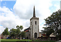
Newmarket: St Mary's Church Room
The building with the cream painted brickwork is St Mary's Church Room, opened in 1901. The spire and east end of the eponymous church are visible beyond, while the larger building to the left is the Turner Hall, built and endowed by Elizabeth Turner in 1931. The road to the right is Church Lane, and the parking meters for the small car park are in front of the church room.
Image: © Nigel Cox
Taken: 6 Jul 2008
0.04 miles
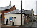
3

Kings Theatre, Fitzroy Street
Owned and operated by the Newmarket Operatic Musical and Dramatic Society (NOMADS)
Image: © Keith Edkins
Taken: 8 Nov 2017
0.05 miles
4
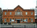
Memorial Hall
king Edward VII memorial hall High Street Newmarket Suffolk.
Image: © Keith Evans
Taken: 16 Feb 2005
0.05 miles
5
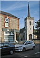
Newmarket: St Mary's Church from the corner of Lowther Street
The church is Grade II* listed: see http://www.britishlistedbuildings.co.uk/en-275717-church-of-st-mary-newmarket-suffolk#.VjTbAyiT7ZY .
Image: © John Sutton
Taken: 31 Oct 2015
0.06 miles
6
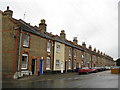
Newmarket: Lowther Street
These terraced houses do not appear on the 1891 Ordnance Survey map but both sides of the street are shown complete on the 1903 edition, suggesting they were built in the 1890s. The near house appears to have had a street name plate over the front door at some stage in the past. The far end of the terrace is in Image
Image: © Nigel Cox
Taken: 6 Jul 2008
0.06 miles
8
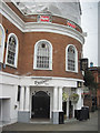
High Street Newmarket at the junction of Grosvenor Yard
Image: © David Howard
Taken: 26 Jul 2012
0.06 miles
9
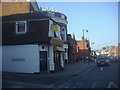
De Niros Nightclub High Street
Lies on the corner of Grosvenor Place
Image: © John Firth
Taken: 13 Sep 2010
0.07 miles
10
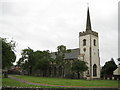
Newmarket: St Mary's Church
Newmarket has two civil parishes, St Mary's and All Saints. St Mary's occupies a site to the west of the High Street and dates in part from the 15th century with three Victorian restorations.
Image: © Nigel Cox
Taken: 6 Jul 2008
0.07 miles