1
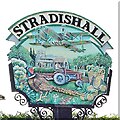
Village sign, Stradishall
Depicting an aeroplane. RAF Stradishall near here was open from 1938 to 1970. It is now the site of a prison (Highpoint North and Highpoint South-see http://www.geograph.org.uk/photo/3407011)
Image: © Bikeboy
Taken: 4 May 2014
0.05 miles
2
Stradishall, noticeboard and village sign
Image: © Bikeboy
Taken: 4 May 2014
0.06 miles
3
Stradishall Village Sign
Stradishall village sign Stradishall, Suffolk for overall view see http://www.geograph.org.uk/photo/1240140
Image: © Keith Evans
Taken: 5 Apr 2009
0.06 miles
4
Stradishall village sign
Image: © Adrian S Pye
Taken: 30 Apr 2007
0.06 miles
5
Stradishall village sign
Illustrated on the sign to recognise the RAF Stradishall airfield is a Heyford night bomber and the last heavy bomber biplane to serve with the Royal Air Force. On the ground is the church of St Margaret in the background and an orchard with a ladder up a tree and a bushel of apples, referring to the parish's south facing slopes make it an ideal place to grow fruit and there are many local orchards. A farmer on a tractor is ploughing his fields but the days of the horse and the farrier are not forgotten by the inclusion of a horseshoe in the picture. The cock pheasant and some local flora complete the scene.
Image: © Adrian S Pye
Taken: 30 Apr 2007
0.06 miles
6
Stradishall Village Sign
Stradishall village sign Stradishall, Suffolk for close up view see http://www.geograph.org.uk/photo/1240146
Image: © Keith Evans
Taken: 5 Apr 2009
0.07 miles
7
B1063 The Street, Stradishall
Image: © Geographer
Taken: 3 Oct 2014
0.09 miles
8
Thatched cottage in The Street, Stradishall
A number of attractive thatched cottages are aligned along the main thoroughfare through the village - The Street. The village is probably best known now for H.M. Prison Highpoint which is located within the parish on what used to be the old 'domestic side' of RAF Stradishall (closed in 1970). H.M. Prison Highpoint is situated at the highest point in Suffolk.
Image: © Evelyn Simak
Taken: 30 Apr 2012
0.10 miles
9
K6 telephone box in The Street, Stradishall
A number of attractive thatched cottages are aligned along the main thoroughfare through the village - The Street. The village is probably best known now for H.M. Prison Highpoint which is located within the parish on what used to be the old 'domestic side' of RAF Stradishall (closed in 1970). H.M. Prison Highpoint is situated at the highest point in Suffolk.
Image: © Evelyn Simak
Taken: 30 Apr 2012
0.11 miles
10
Timberframed thatched cottages in The Street, Stradishall
A number of attractive thatched cottages are aligned along the main thoroughfare through the village - The Street. The village is probably best known now for H.M. Prison Highpoint which is located within the parish on what used to be the old 'domestic side' of RAF Stradishall (closed in 1970). H.M. Prison Highpoint is situated at the highest point in Suffolk.
Image: © Evelyn Simak
Taken: 30 Apr 2012
0.11 miles


