IMAGES TAKEN NEAR TO
Mill Road, NEWMARKET, CB8 8YJ
Introduction
This page details the photographs taken nearby to Mill Road, CB8 8YJ by members of the Geograph project.
The Geograph project started in 2005 with the aim of publishing, organising and preserving representative images for every square kilometre of Great Britain, Ireland and the Isle of Man.

There are currently over 7.5m images from over14,400 individuals and you can help contribute to the project by visiting https://www.geograph.org.uk
Image Map
Images are licensed for reuse under creativecommons.org/licenses/by-sa/2.0
Notes
- Clicking on the map will re-center to the selected point.
- The higher the marker number, the further away the image location is from the centre of the postcode.
Image Listing (8 Images Found)
Images are licensed for reuse under creativecommons.org/licenses/by-sa/2.0
Image
Details
Distance
1
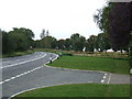
Removed dual carriageway
The road behind the fencing is the remains of a very short length of dual carriageway that has been removed on the A143 Wickham Street, Suffolk.
Image: © Keith Evans
Taken: 4 Oct 2008
0.17 miles
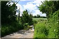
2
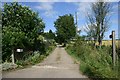
Footpath to Malting End
This path leads north-west from the A143 near Wickham Street.
Image: © Bob Jones
Taken: 14 Jul 2006
0.17 miles
3
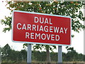
Dual carriageway removed sign
Dual carriageway removed sign indicating a very short section of dual carriageway has been returned to two a lane road near to Wickham Street Suffolk.
Image: © Keith Evans
Taken: 4 Oct 2008
0.17 miles
4
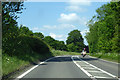
A143 towards Bury St Edmunds
Approaching Wickham Street.
Image: © Robin Webster
Taken: 3 Jun 2018
0.20 miles
5
Ford over River Glem at Wickhambrook
A minor road fords the river at Malting End.
Image: © Bob Jones
Taken: 22 Jun 2006
0.23 miles
6
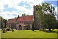
Wickhambrook Church
All Saints, Wickhambrook, is just off the main road through the village, the B1063 Newmarket to Clare road, just north of where it crosses the A143 Bury to Haverhill road.
Image: © Bob Jones
Taken: 22 Jun 2006
0.24 miles
7
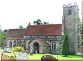
Wickhambrook All Saints church
The church is a mixture, as many are, of 12th to 17th century work with Victorian restorations. The nave is of the earlier period, although the very lightweight Jacobean hammerbeam roof with arch-bracing is 17th century. Everything else fits somewhere in between. The north porch is 14th century. Unfortunately, the clerestory is not very effective, having only eight small mullioned windows and it is quite dark inside. The 13th century font has been cut into a most unusual form; square at the top and octagonal at the bottom of the bowl. Equally old are the north doorway to the nave and the south chancel doorway. Most interesting in the church is the monument to Thomas Higham (1630), guarded by railing to prevent his escape. A brass wall plaque is only readable with great difficulty, due to those ridiculously close protective bars which prevent cleaning.
Image: © Adrian S Pye
Taken: 17 Aug 2007
0.24 miles
8
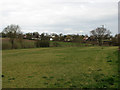
Wickhambrook Glebe Field
A view from the churchyard. Wickhambrook is a straggling village and the church is at its southern edge.
Image: © John Sutton
Taken: 17 Mar 2017
0.25 miles