IMAGES TAKEN NEAR TO
Brookside, NEWMARKET, CB8 8TG
Introduction
This page details the photographs taken nearby to Brookside, CB8 8TG by members of the Geograph project.
The Geograph project started in 2005 with the aim of publishing, organising and preserving representative images for every square kilometre of Great Britain, Ireland and the Isle of Man.

There are currently over 7.5m images from over14,400 individuals and you can help contribute to the project by visiting https://www.geograph.org.uk
Image Map
Images are licensed for reuse under creativecommons.org/licenses/by-sa/2.0
Notes
- Clicking on the map will re-center to the selected point.
- The higher the marker number, the further away the image location is from the centre of the postcode.
Image Listing (32 Images Found)
Images are licensed for reuse under creativecommons.org/licenses/by-sa/2.0
Image
Details
Distance
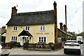
1
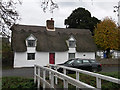
Pear Tree Cottage, Dalham
C18, timber-framed and rendered. Grade II listed.
Image: © Keith Edkins
Taken: 6 Nov 2018
0.02 miles
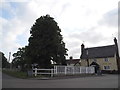
3
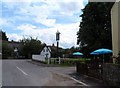
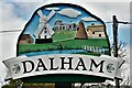
Dalham village
Near to the Affleck Arms and the bridge over the River Kennett
Image: © Bikeboy
Taken: 28 Jun 2014
0.03 miles
4
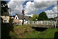
Dalham village
The centre of the village, with the road bridge across the dried-up River Kennett, and the local pub.
Image: © Bob Jones
Taken: 25 Aug 2005
0.03 miles
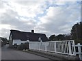
7
Bridge on Stores Hill, Dalham
Crossing the River Kennett
Image: © David Howard
Taken: 8 May 2017
0.04 miles
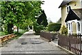
8
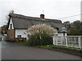
Stores Hill, Dalham
Pair of C18 cottages, timber-framed and rendered. Grade II listed.
Image: © Keith Edkins
Taken: 6 Nov 2018
0.04 miles
10
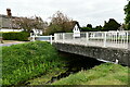
Dalham: Road bridge over the River Kennett
Image: © Michael Garlick
Taken: 27 Apr 2022
0.05 miles