IMAGES TAKEN NEAR TO
Dalham, NEWMARKET, CB8 8TA
Introduction
This page details the photographs taken nearby to CB8 8TA by members of the Geograph project.
The Geograph project started in 2005 with the aim of publishing, organising and preserving representative images for every square kilometre of Great Britain, Ireland and the Isle of Man.

There are currently over 7.5m images from over14,400 individuals and you can help contribute to the project by visiting https://www.geograph.org.uk
Image Map
Images are licensed for reuse under creativecommons.org/licenses/by-sa/2.0
Notes
- Clicking on the map will re-center to the selected point.
- The higher the marker number, the further away the image location is from the centre of the postcode.
Image Listing (4 Images Found)
Images are licensed for reuse under creativecommons.org/licenses/by-sa/2.0
Image
Details
Distance
1
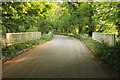
Catford Bridge
The road from Gazeley to Ashley, and the Icknield Way Path, cross the River Kennett at this bridge.
Image: © Rob Noble
Taken: 29 Apr 2011
0.04 miles
2
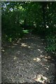
Dried up bed of the River Kennett
Every summer this river - just a stream really - dries up. This view is looking south easterly, i.e. upstream. The Kennett joins up with the River Lark, downstream of West Row, near Mildenhall.
Image: © Bob Jones
Taken: 17 Aug 2005
0.12 miles
3
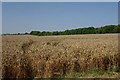
Farmland near Gazeley
Looking north west from the road between Gazeley and Ashley, across an uncut field of wheat.
Image: © Bob Jones
Taken: 17 Aug 2005
0.16 miles
4
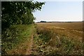
Footpath to Dalham
This path, which runs alongside the River Kennett, is part of the Icknield Way.
Image: © Bob Jones
Taken: 17 Aug 2005
0.18 miles