IMAGES TAKEN NEAR TO
Gazeley Road, NEWMARKET, CB8 8SR
Introduction
This page details the photographs taken nearby to Gazeley Road, CB8 8SR by members of the Geograph project.
The Geograph project started in 2005 with the aim of publishing, organising and preserving representative images for every square kilometre of Great Britain, Ireland and the Isle of Man.

There are currently over 7.5m images from over14,400 individuals and you can help contribute to the project by visiting https://www.geograph.org.uk
Image Map
Images are licensed for reuse under creativecommons.org/licenses/by-sa/2.0
Notes
- Clicking on the map will re-center to the selected point.
- The higher the marker number, the further away the image location is from the centre of the postcode.
Image Listing (141 Images Found)
Images are licensed for reuse under creativecommons.org/licenses/by-sa/2.0
Image
Details
Distance
1
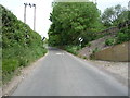
National Cycle Route 51
Heading east from Moulton.
Image: © JThomas
Taken: 21 May 2016
0.07 miles
3
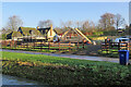
Moulton: unloading roof trusses
A large site on Brookside is being redeveloped. The picture was taken from the footbridge over the River Kennett on a sunny December morning.
Image: © John Sutton
Taken: 15 Dec 2020
0.12 miles
4
![Moulton houses [1]](https://s1.geograph.org.uk/geophotos/06/71/99/6719921_316e9ec9_120x120.jpg)
Moulton houses [1]
This pair of cottages at numbers 17 and 19 Brookside were originally one house. Built in the 16th or 17th century, timber framed and stuccoed with a thatched roof. Listed, grade II, with details at: https://historicengland.org.uk/listing/the-list/list-entry/1037679
Moulton is a small village some 3 miles east of Newmarket and was settled in Saxon times. The River Kennett flows through the village and a 15th-century packhorse bridge spans the river.
Image: © Michael Dibb
Taken: 9 Sep 2020
0.12 miles
5
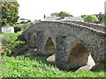
Detail of bridge
The easternmost arch of Moulton packhorse bridge seen from the upstream side.showing the arch rings of medieval brick.
Image: © Tiger
Taken: 27 Jun 2009
0.12 miles
6
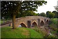
Moulton packhorse bridge
This bridge over the River Kennett was built in the 14th or 15th century alongside a ford on the packhorse route between Bury St Edmunds and Cambridge.
Image: © Tiger
Taken: 27 Jun 2009
0.13 miles
7
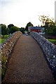
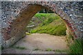
Crossing the packhorse bridge
A view from the east along the packhorse trail into the village, with the King's Arms inn in the distance.
Image: © Tiger
Taken: 27 Jun 2009
0.13 miles
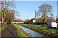
8
River Kennett
Looking from a footbridge to the packhorse bridge.
Image: © Hugh Venables
Taken: 23 Jul 2011
0.14 miles
9
Moulton: by the River Kennett
Looking towards the mediaeval Packhorse Bridge on a bright December morning.
Image: © John Sutton
Taken: 15 Dec 2020
0.14 miles
10
![Moulton features [4]](https://s2.geograph.org.uk/geophotos/06/71/99/6719918_2e5ba125_120x120.jpg)
Moulton features [4]
From Brookside, this footbridge crosses the River Kennett.
Moulton is a small village some 3 miles east of Newmarket and was settled in Saxon times. The River Kennett flows through the village and a 15th-century packhorse bridge spans the river.
Image: © Michael Dibb
Taken: 9 Sep 2020
0.14 miles