IMAGES TAKEN NEAR TO
Park Close, NEWMARKET, CB8 8SL
Introduction
This page details the photographs taken nearby to Park Close, CB8 8SL by members of the Geograph project.
The Geograph project started in 2005 with the aim of publishing, organising and preserving representative images for every square kilometre of Great Britain, Ireland and the Isle of Man.

There are currently over 7.5m images from over14,400 individuals and you can help contribute to the project by visiting https://www.geograph.org.uk
Image Map
Images are licensed for reuse under creativecommons.org/licenses/by-sa/2.0
Notes
- Clicking on the map will re-center to the selected point.
- The higher the marker number, the further away the image location is from the centre of the postcode.
Image Listing (102 Images Found)
Images are licensed for reuse under creativecommons.org/licenses/by-sa/2.0
Image
Details
Distance
1
![Moulton houses [8]](https://s2.geograph.org.uk/geophotos/06/72/14/6721470_17acce0f_120x120.jpg)
Moulton houses [8]
Cherry Street Cottage, number 8 The Street is an attractive, thatched property.
Moulton is a small village some 3 miles east of Newmarket and was settled in Saxon times. The River Kennett flows through the village and a 15th-century packhorse bridge spans the river.
Image: © Michael Dibb
Taken: 9 Sep 2020
0.03 miles
3
![Moulton features [9]](https://s0.geograph.org.uk/geophotos/06/72/14/6721468_6a0595d2_120x120.jpg)
Moulton features [9]
The meadows in the village centre contain a pond, seen here from The Street.
Moulton is a small village some 3 miles east of Newmarket and was settled in Saxon times. The River Kennett flows through the village and a 15th-century packhorse bridge spans the river.
Image: © Michael Dibb
Taken: 9 Sep 2020
0.09 miles
4
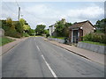
Bus stop and shelter on Newmarket Road, Moulton
National Cycle Route 51.
Image: © JThomas
Taken: 21 May 2016
0.10 miles
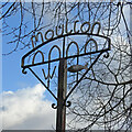
5
Moulton village sign
The sign is wrought iron and features the grade II* Pack Horse Bridge which spans the River Kennett. Just about wide enough for a cart it is now used only by pedestrians. A concrete ford now allows cars to cross the stream to the church. The fish represents the unusual weathervane on the church which takes the form of a large pike. The “WI” represents the Women’s Institute.
https://www.geograph.org.uk/photo/6663343
Image: © Adrian S Pye
Taken: 3 Nov 2020
0.11 miles
7
![Moulton houses [9]](https://s1.geograph.org.uk/geophotos/06/72/14/6721473_2749cbf3_120x120.jpg)
Moulton houses [9]
Number 1 School Road is a 17th century house with an early 19th century extension, Timber framed and stuccoed. Listed, grade II, with details at: https://historicengland.org.uk/listing/the-list/list-entry/1193451
Moulton is a small village some 3 miles east of Newmarket and was settled in Saxon times. The River Kennett flows through the village and a 15th-century packhorse bridge spans the river.
Image: © Michael Dibb
Taken: 9 Sep 2020
0.13 miles
8
Moulton village sign
The sign is wrought iron and features the grade II* Pack Horse Bridge which spans the River Kennett. Just about wide enough for a cart it is now used only by pedestrians. A concrete ford now allows cars to cross the stream to the church. The fish represents the unusual weathervane on the church which takes the form of a large pike. The “WI” represents the Women’s Institute. https://www.geograph.org.uk/photo/6663345
Image: © Adrian S Pye
Taken: 3 Nov 2020
0.13 miles
9
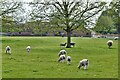
Moulton: Large field for sheep and lambs
Image: © Michael Garlick
Taken: 13 May 2021
0.14 miles
10
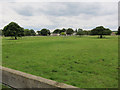
Parkland, Moulton
With suggestions of past earthworks.
Image: © Hugh Venables
Taken: 23 Jul 2011
0.15 miles