IMAGES TAKEN NEAR TO
Kennett Road, NEWMARKET, CB8 8QR
Introduction
This page details the photographs taken nearby to Kennett Road, CB8 8QR by members of the Geograph project.
The Geograph project started in 2005 with the aim of publishing, organising and preserving representative images for every square kilometre of Great Britain, Ireland and the Isle of Man.

There are currently over 7.5m images from over14,400 individuals and you can help contribute to the project by visiting https://www.geograph.org.uk
Image Map
Images are licensed for reuse under creativecommons.org/licenses/by-sa/2.0
Notes
- Clicking on the map will re-center to the selected point.
- The higher the marker number, the further away the image location is from the centre of the postcode.
Image Listing (5 Images Found)
Images are licensed for reuse under creativecommons.org/licenses/by-sa/2.0
Image
Details
Distance
2
Footpath along the River Kennett
Heading away from Moulton.
Image: © Hugh Venables
Taken: 23 Jul 2011
0.11 miles
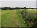
4
Footbridge across the River Kennett
No more than a narrow stream, the 'river' is crossed at this point by a footbridge, on private farmland adjacent to the B1085, north of the village of Moulton.
Image: © Bob Jones
Taken: 16 Mar 2009
0.15 miles
5
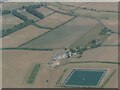
Patterned ground and circular cropmarks on field north of Moulton, Suffolk: aerial 2022
Circles are hard to spot in pale section at top of main field, but are very clear on some satellite images of this site.
Image: © Simon Tomson
Taken: 19 Jul 2022
0.15 miles