IMAGES TAKEN NEAR TO
Stradishall, NEWMARKET, CB8 8PS
Introduction
This page details the photographs taken nearby to CB8 8PS by members of the Geograph project.
The Geograph project started in 2005 with the aim of publishing, organising and preserving representative images for every square kilometre of Great Britain, Ireland and the Isle of Man.

There are currently over 7.5m images from over14,400 individuals and you can help contribute to the project by visiting https://www.geograph.org.uk
Image Map
Images are licensed for reuse under creativecommons.org/licenses/by-sa/2.0
Notes
- Clicking on the map will re-center to the selected point.
- The higher the marker number, the further away the image location is from the centre of the postcode.
Image Listing (7 Images Found)
Images are licensed for reuse under creativecommons.org/licenses/by-sa/2.0
Image
Details
Distance
1
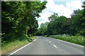
A143 towards Bury St Edmunds
In the parish of Stradishall with the village ahead.
Image: © Robin Webster
Taken: 3 Jun 2018
0.05 miles
2
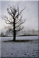
Trees near Stradishall
The large tree stands alone in a field, whilst the line of poplars beyond acts as a windbreak against the southerly gales.
Image: © Bob Jones
Taken: 8 Feb 2009
0.11 miles
3
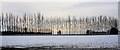
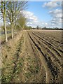
Line of poplars, Stradishall
Viewed from the A143 opposite Howes Farm, these trees act as a windbreak.
Image: © Bob Jones
Taken: 8 Feb 2009
0.14 miles
4
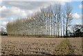
Footpath to the poplars
A public footpath crosses the field, leading towards a row of poplars near Howe's Farm, Stradishall.
Image: © Bob Jones
Taken: 8 Feb 2011
0.16 miles
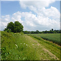
5
Field margin near Howe's Farm, Stradishall
This field borders the A143, which can be seen to the left.
Image: © Bob Jones
Taken: 8 Feb 2011
0.18 miles
6
Field edge behind Mill Lane hedge
The crop looks like wheat.
Image: © Robin Webster
Taken: 3 Jun 2018
0.24 miles
7
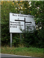
Roadsign on the A143 Bury Road
Approaching the junction with the B1063
Image: © Geographer
Taken: 3 Oct 2014
0.25 miles