IMAGES TAKEN NEAR TO
Giffords Lane, NEWMARKET, CB8 8PQ
Introduction
This page details the photographs taken nearby to Giffords Lane, CB8 8PQ by members of the Geograph project.
The Geograph project started in 2005 with the aim of publishing, organising and preserving representative images for every square kilometre of Great Britain, Ireland and the Isle of Man.

There are currently over 7.5m images from over14,400 individuals and you can help contribute to the project by visiting https://www.geograph.org.uk
Image Map
Images are licensed for reuse under creativecommons.org/licenses/by-sa/2.0
Notes
- Clicking on the map will re-center to the selected point.
- The higher the marker number, the further away the image location is from the centre of the postcode.
Image Listing (5 Images Found)
Images are licensed for reuse under creativecommons.org/licenses/by-sa/2.0
Image
Details
Distance
1
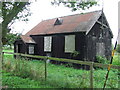
Was this a tabernacle
Was this a former tabernacle now boarded up with straw inside Clopton Green,Suffolk.
Image: © Keith Evans
Taken: 4 Oct 2008
0.05 miles
2
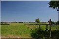
Footpath at Clopton Green
This path leads east towards Rede.
Image: © Bob Jones
Taken: 29 Jun 2006
0.17 miles
3
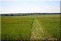
Footpath to Wickham Street
Farmers appear more willing than a few years ago to leave a path through cultivated fields. Perhaps this is something to do with payments awarded under the Environmental Stewardship Scheme.
Image: © Bob Jones
Taken: 29 Jun 2006
0.18 miles
4
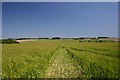
Footpath from Clopton Green to Rede.
Another example of a mown footpath through a cultivated field.
Image: © Bob Jones
Taken: 29 Jun 2006
0.23 miles
5
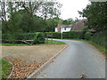
Gifford's Hall entrance
The entrance on the left is to Gifford's Hall Clopton Green, Suffolk.
Image: © Keith Evans
Taken: 4 Oct 2008
0.24 miles