IMAGES TAKEN NEAR TO
Warren Road, NEWMARKET, CB8 7QP
Introduction
This page details the photographs taken nearby to Warren Road, CB8 7QP by members of the Geograph project.
The Geograph project started in 2005 with the aim of publishing, organising and preserving representative images for every square kilometre of Great Britain, Ireland and the Isle of Man.

There are currently over 7.5m images from over14,400 individuals and you can help contribute to the project by visiting https://www.geograph.org.uk
Image Map
Images are licensed for reuse under creativecommons.org/licenses/by-sa/2.0
Notes
- Clicking on the map will re-center to the selected point.
- The higher the marker number, the further away the image location is from the centre of the postcode.
Image Listing (4 Images Found)
Images are licensed for reuse under creativecommons.org/licenses/by-sa/2.0
Image
Details
Distance
2
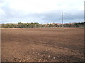
Flat farmland near Red Lodge
Looking east towards Ella's Plantation.
Image: © JThomas
Taken: 5 Mar 2016
0.13 miles
3
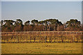
Paddocks near Herringswell
Looking north-westwards from the Herringswell Road, across paddocks.
Image: © Bob Jones
Taken: 20 Jan 2009
0.24 miles
4
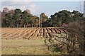
Farmland near Red Lodge
Looking eastwards from Warren Road, near Red Lodge, the ploughed field is being prepared for potato planting.
Image: © Bob Jones
Taken: 6 Mar 2009
0.24 miles