IMAGES TAKEN NEAR TO
Clifton Mews, NEWMARKET, CB8 7FF
Introduction
This page details the photographs taken nearby to Clifton Mews, CB8 7FF by members of the Geograph project.
The Geograph project started in 2005 with the aim of publishing, organising and preserving representative images for every square kilometre of Great Britain, Ireland and the Isle of Man.

There are currently over 7.5m images from over14,400 individuals and you can help contribute to the project by visiting https://www.geograph.org.uk
Image Map
Images are licensed for reuse under creativecommons.org/licenses/by-sa/2.0
Notes
- Clicking on the map will re-center to the selected point.
- The higher the marker number, the further away the image location is from the centre of the postcode.
Image Listing (33 Images Found)
Images are licensed for reuse under creativecommons.org/licenses/by-sa/2.0
Image
Details
Distance
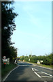
3
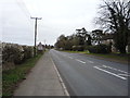
Bury Road (B1506)
Heading east from Kentford.
Image: © JThomas
Taken: 19 Mar 2016
0.07 miles
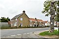
4
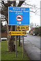
C road sign at Kentford
The C612 road to Herringswell is a turning off the B1506, in the centre of the village of Kentford.
Image: © Bob Jones
Taken: 13 Jan 2009
0.08 miles

8
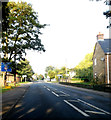
B1506 Bury Road, Kentford
At the junction with Gazeley & Herringwell Roads
Image: © Geographer
Taken: 14 Sep 2014
0.10 miles
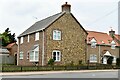
9
Entering Kentford on the B1506 Bury Road
Image: © Geographer
Taken: 14 Sep 2014
0.10 miles
10
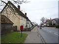
Bury Road (B1506), Kentford
Looking west showing position of Postbox No. CB8 95.
The Kentford public house behind.
See Image] for postbox.
Image: © JThomas
Taken: 19 Mar 2016
0.12 miles