IMAGES TAKEN NEAR TO
Bury Road, NEWMARKET, CB8 7DG
Introduction
This page details the photographs taken nearby to Bury Road, CB8 7DG by members of the Geograph project.
The Geograph project started in 2005 with the aim of publishing, organising and preserving representative images for every square kilometre of Great Britain, Ireland and the Isle of Man.

There are currently over 7.5m images from over14,400 individuals and you can help contribute to the project by visiting https://www.geograph.org.uk
Image Map
Images are licensed for reuse under creativecommons.org/licenses/by-sa/2.0
Notes
- Clicking on the map will re-center to the selected point.
- The higher the marker number, the further away the image location is from the centre of the postcode.
Image Listing (5 Images Found)
Images are licensed for reuse under creativecommons.org/licenses/by-sa/2.0
Image
Details
Distance
2
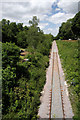
Single-track railway line, Newmarket
The railway from Cambridge and Newmarket Station emerges from the tunnel under Warren Hill, immediately after passing below the A1304 Bury Road. The line remains single-track as far as Chippenham Junction; thereafter it is double-track to Ipswich.
Image: © Bob Jones
Taken: 30 Jun 2008
0.12 miles
3
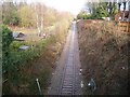
Warren Hill station
A station was built on this site at the northern end of the Warren Hill tunnel in 1885, to cater for the "Race Special" trains from northern England. It closed c.1945, and was demolished soon afterwards.
The photo was taken looking northwards from above the tunnel entrance. The station stood in the flat area to the left of the line. The Ely junction was in the distance at the end of the straight.
Image: © Tony Lewis
Taken: 19 Jan 2009
0.15 miles
5
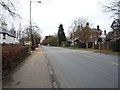
Bury Road (A1304), Newmarket
Heading north east.
Image: © JThomas
Taken: 19 Mar 2016
0.22 miles