IMAGES TAKEN NEAR TO
Rowley Drive, NEWMARKET, CB8 0PU
Introduction
This page details the photographs taken nearby to Rowley Drive, CB8 0PU by members of the Geograph project.
The Geograph project started in 2005 with the aim of publishing, organising and preserving representative images for every square kilometre of Great Britain, Ireland and the Isle of Man.

There are currently over 7.5m images from over14,400 individuals and you can help contribute to the project by visiting https://www.geograph.org.uk
Image Map
Images are licensed for reuse under creativecommons.org/licenses/by-sa/2.0
Notes
- Clicking on the map will re-center to the selected point.
- The higher the marker number, the further away the image location is from the centre of the postcode.
Image Listing (19 Images Found)
Images are licensed for reuse under creativecommons.org/licenses/by-sa/2.0
Image
Details
Distance


6

Angled housing
Angled housing of Rowley Drive Newmarket, Suffolk.
Image: © Keith Evans
Taken: 17 Jan 2010
0.12 miles
7
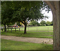
Playpark
Play area and Park in Adastral Road, Newmarket, Suffolk
Image: © mike
Taken: 7 Sep 2005
0.13 miles
8

Valley Way shops, Newmarket
This row of half a dozen shops in situated in the centre of a housing estate on the western outskirts of the town.
Image: © Bob Jones
Taken: 30 Jun 2010
0.19 miles

10
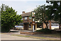
The Palomino public house
Situated in Valley Way, Newmarket, this is a popular local pub in the centre of a housing estate, next to a row of shops.
Image: © Bob Jones
Taken: 30 Jun 2010
0.21 miles