IMAGES TAKEN NEAR TO
Exning Road, NEWMARKET, CB8 0EA
Introduction
This page details the photographs taken nearby to Exning Road, CB8 0EA by members of the Geograph project.
The Geograph project started in 2005 with the aim of publishing, organising and preserving representative images for every square kilometre of Great Britain, Ireland and the Isle of Man.

There are currently over 7.5m images from over14,400 individuals and you can help contribute to the project by visiting https://www.geograph.org.uk
Image Map
Images are licensed for reuse under creativecommons.org/licenses/by-sa/2.0
Notes
- Clicking on the map will re-center to the selected point.
- The higher the marker number, the further away the image location is from the centre of the postcode.
Image Listing (24 Images Found)
Images are licensed for reuse under creativecommons.org/licenses/by-sa/2.0
Image
Details
Distance
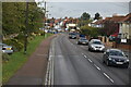
2
Southern end of George Lambton Avenue, Newmarket
Seen from near its junction with Exning Road.
Image: © Richard Vince
Taken: 3 Feb 2018
0.04 miles
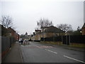
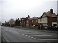
3

Houses on Exning Road, Newmarket (2)
Accessed via this concrete surfaced service road.
Image: © Richard Vince
Taken: 3 Feb 2018
0.04 miles

6
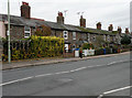
Bakers Row, Exning Road
Flint-built, former farmers' cottages. Victorian? - already present on 1884 OS Map.
Image: © Keith Edkins
Taken: 8 Nov 2017
0.08 miles
7

New Aldi, Newmarket
The High Street has many empty shops, but this store has just opened
Image: © Hugh Venables
Taken: 26 Jun 2021
0.10 miles
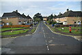
9
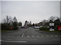
Newmarket Leisure Centre car park entrance
Off Exning Road.
Image: © Richard Vince
Taken: 3 Feb 2018
0.13 miles
10

Footpath to Beaverbrook Road, Newmarket
From George Lambton Avenue.
Image: © Richard Vince
Taken: 3 Feb 2018
0.14 miles