
IMAGES TAKEN NEAR TO
Chatteris Road, ELY, CB6 2FF
Introduction
This page details the photographs taken nearby to Chatteris Road, CB6 2FF by members of the Geograph project.
The Geograph project started in 2005 with the aim of publishing, organising and preserving representative images for every square kilometre of Great Britain, Ireland and the Isle of Man.

There are currently over 7.5m images from over14,400 individuals and you can help contribute to the project by visiting https://www.geograph.org.uk
Image Map
Images are licensed for reuse under creativecommons.org/licenses/by-sa/2.0
Notes
- Clicking on the map will re-center to the selected point.
- The higher the marker number, the further away the image location is from the centre of the postcode.
Image Listing (1 Images Found)
Images are licensed for reuse under creativecommons.org/licenses/by-sa/2.0
Image
Details
Distance
1
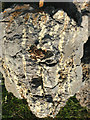
Jarosite, KFe3+3(OH)6(SO4)2
Jarosite is a straw-yellow basic sulphate that forms on the oxidation of iron sulphides (FeS2) in soils and sediments. This soil sample was removed from the subsoil of a trial pit at the Arthur Rickwood Experimental Husbandry Farm, Mepal Fen, Cambs. Oxidation has been brought about by drainage of the land for agriculture and associated features are strong acidity (pH less than 4) caused by the release of sulphuric acid, orange-coloured deposits of ochre in drainage pipes and drains, and aluminium toxicity causing a stunted, deformed root system. Soils with strong acidity formed by this process are known as 'acid sulphate soils'; they are common in the perimarine zone of the Fenland of Eastern England where the original sulphides were supplied by a series of marine transgressions. Jarosite is a prominent feature of mineral sediments such as the Fen Clay but is absent from fen peat which also experiences strong acidification in these areas.
Image: © Rodney Burton
Taken: 9 Jun 2007
0.15 miles