IMAGES TAKEN NEAR TO
The Hythe, ELY, CB6 2DT
Introduction
This page details the photographs taken nearby to The Hythe, CB6 2DT by members of the Geograph project.
The Geograph project started in 2005 with the aim of publishing, organising and preserving representative images for every square kilometre of Great Britain, Ireland and the Isle of Man.

There are currently over 7.5m images from over14,400 individuals and you can help contribute to the project by visiting https://www.geograph.org.uk
Image Map
Images are licensed for reuse under creativecommons.org/licenses/by-sa/2.0
Notes
- Clicking on the map will re-center to the selected point.
- The higher the marker number, the further away the image location is from the centre of the postcode.
Image Listing (6 Images Found)
Images are licensed for reuse under creativecommons.org/licenses/by-sa/2.0
Image
Details
Distance
1
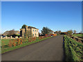
A new beech hedge on Downham Hythe Drove
The nearer house is being restored and the hedge replaces conifers.
Image: © John Sutton
Taken: 23 Nov 2017
0.09 miles
2
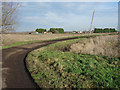
Back road in the Fens
Looking towards Cophall Farm and its collection of vehicles.
Image: © Hugh Venables
Taken: 11 Jan 2009
0.15 miles
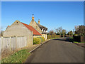
3
Fenland produce for sale
The chalkboard outside this house at Windyridge offers eggs, hay and straw, onions, parsnips, leeks and potatoes. Windyridge, in the Isle of Ely, is 15m/50ft above the Fen levels.
Image: © John Sutton
Taken: 23 Nov 2017
0.22 miles
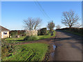
4
Dormers at Downham Hythe
The winding road from Coveney to Little Downham on a bright November morning.
Image: © John Sutton
Taken: 23 Nov 2017
0.23 miles
5
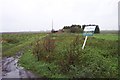
Ruin for sale
This property is in need of updating!
Image: © Jonathan Billinger
Taken: 16 Nov 2006
0.24 miles
6
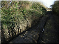
Fenland byway
Very deep hole dug out by off-roaders. Not somewhere to take on unless you really know what you're doing.
Image: © Hugh Venables
Taken: 11 Jan 2009
0.24 miles