IMAGES TAKEN NEAR TO
Wentworth Road, ELY, CB6 2DQ
Introduction
This page details the photographs taken nearby to Wentworth Road, CB6 2DQ by members of the Geograph project.
The Geograph project started in 2005 with the aim of publishing, organising and preserving representative images for every square kilometre of Great Britain, Ireland and the Isle of Man.

There are currently over 7.5m images from over14,400 individuals and you can help contribute to the project by visiting https://www.geograph.org.uk
Image Map
Images are licensed for reuse under creativecommons.org/licenses/by-sa/2.0
Notes
- Clicking on the map will re-center to the selected point.
- The higher the marker number, the further away the image location is from the centre of the postcode.
Image Listing (13 Images Found)
Images are licensed for reuse under creativecommons.org/licenses/by-sa/2.0
Image
Details
Distance

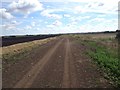
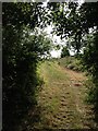
2
Grudges Bank byway
Past Wolvey Holes Farm. Little used as doesn't go far before you get back to a road.
Image: © Hugh Venables
Taken: 21 Dec 2008
0.06 miles
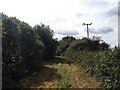
3
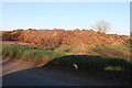
Funny business
It's business anyway. It has its own concrete floor.
Image: © David Howard
Taken: 27 Feb 2022
0.06 miles
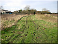
6
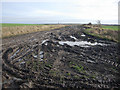
Muddy byway
Leading to Coveney Sedge Fen
Image: © Hugh Venables
Taken: 21 Dec 2008
0.11 miles
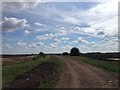
7
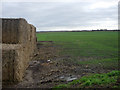
Autumn sown crop
Flat Fenland field. Bales of straw on an area of concrete hardstanding where crops or machinery are temporarily stored.
Image: © Hugh Venables
Taken: 21 Dec 2008
0.13 miles
9
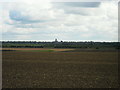
Coveney, Arable Fields
Looking in an Easterly direction from Long Lane, Coveney over arable fields towards Ely. The Cathedral can clearly be seen 6km away.
Image: © Andrea
Taken: 7 Oct 2014
0.20 miles