IMAGES TAKEN NEAR TO
River Close, ELY, CB6 2AN
Introduction
This page details the photographs taken nearby to River Close, CB6 2AN by members of the Geograph project.
The Geograph project started in 2005 with the aim of publishing, organising and preserving representative images for every square kilometre of Great Britain, Ireland and the Isle of Man.

There are currently over 7.5m images from over14,400 individuals and you can help contribute to the project by visiting https://www.geograph.org.uk
Image Map
Images are licensed for reuse under creativecommons.org/licenses/by-sa/2.0
Notes
- Clicking on the map will re-center to the selected point.
- The higher the marker number, the further away the image location is from the centre of the postcode.
Image Listing (57 Images Found)
Images are licensed for reuse under creativecommons.org/licenses/by-sa/2.0
Image
Details
Distance
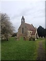
1
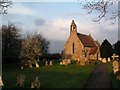
St Mary, Mepal.
http://www.druidic.org/camchurch/churches/mepal.htm
Image: © mym
Taken: 5 Mar 2004
0.02 miles

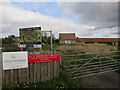
5
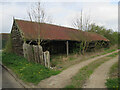
Old barn in Mepal
To make way for new houses.
Image: © Hugh Venables
Taken: 1 Apr 2017
0.07 miles
6
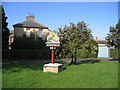
Village sign, Mepal, Cambs
located on the small green at the junction of Sutton Road and School Lane.
Image: © Rodney Burton
Taken: 27 Aug 2006
0.07 miles
7
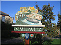
Village sign detail, Mepal, Cambs
The sign shows Vermuyden's wooden bridge and sheep being transported by boat.
Image: © Rodney Burton
Taken: 27 Aug 2006
0.07 miles
9
Manor Farm, Mepal
With conversion of the farm buildings and development of houses in front imminent.
Image: © Hugh Venables
Taken: 1 Apr 2017
0.08 miles
10
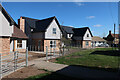
New houses in Mepal
See Image for an earlier view.
Image: © Hugh Venables
Taken: 6 Apr 2021
0.08 miles