IMAGES TAKEN NEAR TO
Wisbech Road, ELY, CB6 1RQ
Introduction
This page details the photographs taken nearby to Wisbech Road, CB6 1RQ by members of the Geograph project.
The Geograph project started in 2005 with the aim of publishing, organising and preserving representative images for every square kilometre of Great Britain, Ireland and the Isle of Man.

There are currently over 7.5m images from over14,400 individuals and you can help contribute to the project by visiting https://www.geograph.org.uk
Image Map
Images are licensed for reuse under creativecommons.org/licenses/by-sa/2.0
Notes
- Clicking on the map will re-center to the selected point.
- The higher the marker number, the further away the image location is from the centre of the postcode.
Image Listing (7 Images Found)
Images are licensed for reuse under creativecommons.org/licenses/by-sa/2.0
Image
Details
Distance
1
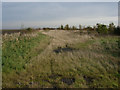
Small woodland area
Amongst the arable fields of the fens.
Image: © Hugh Venables
Taken: 25 Oct 2008
0.13 miles
2
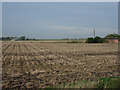
Stubble field
Whooper Swans flying between fields. The swans feed in the fields and roost on the Ouse Washes.
Image: © Hugh Venables
Taken: 25 Oct 2008
0.17 miles
3
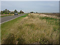
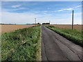
Bates Drove, A1101
Crossing the fens.
Image: © Hugh Venables
Taken: 25 Oct 2008
0.17 miles
5
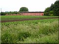
Broadlands
Farm on Bates's Drove, A1101 Littleport to Wisbech road. Potato field in foreground.
Image: © Oliver Dixon
Taken: 7 Jun 2007
0.21 miles
6
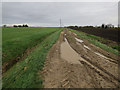
Bell's Drove
Looking towards Grubb's Farm.
Image: © Hugh Venables
Taken: 18 Aug 2012
0.21 miles
7

Rape on the rising ground
Near Grubb's Farm on Bell's Drove between Welney and Littleport
Image: © Richard Humphrey
Taken: 17 May 2013
0.23 miles