IMAGES TAKEN NEAR TO
The Risings, CB6 1LW
Introduction
This page details the photographs taken nearby to The Risings, CB6 1LW by members of the Geograph project.
The Geograph project started in 2005 with the aim of publishing, organising and preserving representative images for every square kilometre of Great Britain, Ireland and the Isle of Man.

There are currently over 7.5m images from over14,400 individuals and you can help contribute to the project by visiting https://www.geograph.org.uk
Image Map
Images are licensed for reuse under creativecommons.org/licenses/by-sa/2.0
Notes
- Clicking on the map will re-center to the selected point.
- The higher the marker number, the further away the image location is from the centre of the postcode.
Image Listing (18 Images Found)
Images are licensed for reuse under creativecommons.org/licenses/by-sa/2.0
Image
Details
Distance
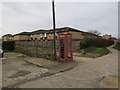
1
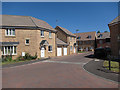
Cottier Drive
New housing on the edge of Littleport. Where Littleport Adult Education Centre was, see Image
Image: © Hugh Venables
Taken: 18 Aug 2012
0.09 miles
3
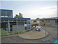
Littleport Adult Education Centre in course of demolition
Formerly a college.
Image: © Oliver Dixon
Taken: 7 Jun 2007
0.14 miles
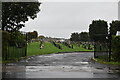
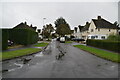
8
Cemetery, Littleport
Off Parson's Lane.
Image: © Hugh Venables
Taken: 18 Aug 2012
0.16 miles
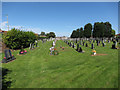
9
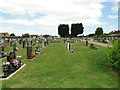
Littleport Cemetery
The cemetery contains seven graves of men killed in the Great War and of three killed in the Second World War.
https://media.geograph.org.uk/files/fe9fc289c3ff0af142b6d3bead98a923/Littleport_cemetery.pdf
Image: © Adrian S Pye
Taken: 2 Jul 2017
0.17 miles
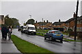
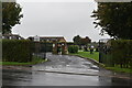
10
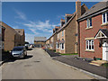
New housing, Littleport
Where Littleport Adult Education Centre was, see Image Still under construction.
Image: © Hugh Venables
Taken: 18 Aug 2012
0.18 miles