IMAGES TAKEN NEAR TO
Misty Meadows, Howard Road, CAMBRIDGE, CB5 8UR
Introduction
This page details the photographs taken nearby to Misty Meadows, Howard Road, CB5 8UR by members of the Geograph project.
The Geograph project started in 2005 with the aim of publishing, organising and preserving representative images for every square kilometre of Great Britain, Ireland and the Isle of Man.

There are currently over 7.5m images from over14,400 individuals and you can help contribute to the project by visiting https://www.geograph.org.uk
Image Map
Images are licensed for reuse under creativecommons.org/licenses/by-sa/2.0
Notes
- Clicking on the map will re-center to the selected point.
- The higher the marker number, the further away the image location is from the centre of the postcode.
Image Listing (127 Images Found)
Images are licensed for reuse under creativecommons.org/licenses/by-sa/2.0
Image
Details
Distance
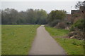
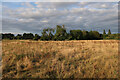
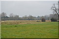
4
Ditton Meadows
Cattle grazing the meadows.
Image: © Hugh Venables
Taken: 17 Aug 2008
0.06 miles
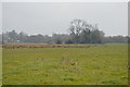
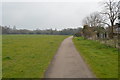
10
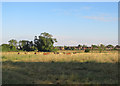
Grazing on Ditton Meadows
A view from the riverside path towards the houses on the northern edge of Ditton Fields, taken on a fine July evening.
Image: © John Sutton
Taken: 12 Jul 2018
0.11 miles