IMAGES TAKEN NEAR TO
Brentwood Close, CAMBRIDGE, CB5 8UE
Introduction
This page details the photographs taken nearby to Brentwood Close, CB5 8UE by members of the Geograph project.
The Geograph project started in 2005 with the aim of publishing, organising and preserving representative images for every square kilometre of Great Britain, Ireland and the Isle of Man.

There are currently over 7.5m images from over14,400 individuals and you can help contribute to the project by visiting https://www.geograph.org.uk
Image Map
Images are licensed for reuse under creativecommons.org/licenses/by-sa/2.0
Notes
- Clicking on the map will re-center to the selected point.
- The higher the marker number, the further away the image location is from the centre of the postcode.
Image Listing (86 Images Found)
Images are licensed for reuse under creativecommons.org/licenses/by-sa/2.0
Image
Details
Distance
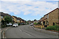
1
Ditton Fields: The Rodings
New houses on an estate on the north-east corner of Cambridge. The streets are named after places in Essex.
Image: © John Sutton
Taken: 5 Aug 2018
0.03 miles
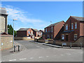
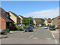
2
On Thorpe Way
Thorpe Way and Fison Road encircle this estate off Ditton Lane in the north-eastern corner of Cambridge.
Image: © John Sutton
Taken: 3 Oct 2021
0.05 miles
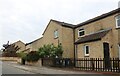
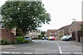
5
Ditton Fields: Sunday morning on Thorpe Way
An estate on the north-east edge of Cambridge.
Image: © John Sutton
Taken: 5 Aug 2018
0.07 miles
7
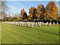
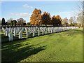
Second World War Graves at Cambridge City cemetery
The 1st Eastern General Hospital, with 1,173 beds, was posted to Cambridge during the First World War, initially at the Leys School and Trinity College, later in huts. The First World War burials in Cambridge City Cemetery are mostly in two plots, one in the southern part of the burial ground, known as the Dominion Plot, and the other on the northern boundary. The Cross of Sacrifice stands on the western border of the Dominion Plot, while in the centre of the other is a memorial cross of Portland stone which was erected by private subscription.
The Second World War graves are also mainly in two War Graves Plots with a few others scattered throughout the cemetery The general Service plot was established in 1940, and the Air Force plot in 1942 for the burial of casualties from the Air Force stations set up in the eastern counties during the war. These included Bomber Command bases in Lincolnshire and fighter stations in Norfolk and Suffolk. The Stone of Remembrance, which was unveiled by Marshal of the Royal Air Force Lord Tedder in July 1951, stands near the centre of the Air Force plot.
Cambridge City Cemetery contains 181 Commonwealth burials of the First World War and 829, (inclusive 3 unidentified), from the Second World War. The cemetery also contains four non-war service burials and ten war graves of other nationalities. (Commonwealth War Graves Commission)
Image: © Adrian S Pye
Taken: 28 Nov 2016
0.10 miles
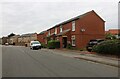
8
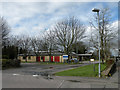
East Barnwell Health Centre
Located between Ditton Lane and Thorpe Way.
Image: © Keith Edkins
Taken: 3 Apr 2010
0.11 miles
9
Second World War Air Force graves
The Second World War graves are also mainly in two War Graves Plots with a few others scattered throughout the cemetery The general Service plot was established in 1940, and the Air Force plot in 1942 for the burial of casualties from the Air Force stations set up in the eastern counties during the war. These included Bomber Command bases in Lincolnshire and fighter stations in Norfolk and Suffolk. The Stone of Remembrance, which was unveiled by Marshal of the Royal Air Force Lord Tedder in July 1951, stands near the centre of the Air Force plot.
Cambridge City Cemetery contains 181 Commonwealth burials of the First World War and 829, (inclusive 3 unidentified), from the Second World War. The cemetery also contains four non-war service burials and ten war graves of other nationalities including Czechoslovakia, Poland, the Netherlands, Australia, New Zealand, South Africa and Belgium.
For a full list of all the names http://media.geograph.org.uk/files/fe9fc289c3ff0af142b6d3bead98a923/Cambridge_city_WW2.pdf
Image: © Adrian S Pye
Taken: 28 Nov 2016
0.11 miles
10
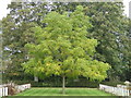
Juglandaceae Juglans nigra - black walnut tree
To see the fruit http://www.geograph.org.uk/photo/5551545
Image: © Adrian S Pye
Taken: 27 Sep 2017
0.11 miles