IMAGES TAKEN NEAR TO
Leonard Close, CAMBRIDGE, CB5 8TR

Introduction

This page details the photographs taken nearby to Leonard Close, CB5 8TR by members of the Geograph project.

The Geograph project started in 2005 with the aim of publishing, organising and preserving representative images for every square kilometre of Great Britain, Ireland and the Isle of Man.

There are currently over 7.5m images from over14,400 individuals and you can help contribute to the project by visiting https://www.geograph.org.uk

Image Map


Images are licensed for reuse under creativecommons.org/licenses/by-sa/2.0
Notes
  • Clicking on the map will re-center to the selected point.
  • The higher the marker number, the further away the image location is from the centre of the postcode.

Image Listing (91 Images Found)

Images are licensed for reuse under creativecommons.org/licenses/by-sa/2.0
  • ...
Image
Details
Distance
1
Ann's Road, Fen Ditton
Image: © David Howard Taken: 12 Sep 2021
0.04 miles
2
Old railway gate
South of Fen Ditton part of the trackbed of the Cambridge-Mildenhall branch (closed 1964) is a permissive path. This gateway was probably a farm crossing in the days of steam.
Image: © John Sutton Taken: 23 Oct 2011
0.06 miles
3
Dennis Road, Fen Ditton
From Fison Road
Image: © David Howard Taken: 12 Sep 2021
0.06 miles
4
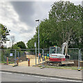
Fen Ditton: a new path where trains once ran
A new cycle and walking route has been created on what was, until the 1960s, the trackbed of the Cambridge to Mildenhall railway line. A simple station was behind the camera, west of Ditton Lane. Image] shows it and the bridge which once carried the lane over the railway. Other views: Image] (2010) Image] (2021)
Image: © John Sutton Taken: 5 Jul 2023
0.07 miles
5
Houses on Fison Road, Fen Ditton
Image: © David Howard Taken: 12 Sep 2021
0.07 miles
6
Fen Ditton: where the railway ran
The area ahead, recently cleared, was the trackbed of the Cambridge to Mildenhall railway line, which closed in 1964. Image] was taken across the field to the left in 2010, when the trackbed was overgrown but nevertheless used as a shaded path. The bridge which crossed the railway here was removed long ago, as were all traces of the tiny Fen Ditton Halt (behind the camera), which the late Walter Dendy photographed before the War: Image
Image: © John Sutton Taken: 28 Apr 2021
0.07 miles
7
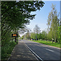
Ditton Lane: advice to motorists
Ditton Lane is a route into the eastern suburbs of Cambridge from the A14 and the matrix sign on the left usually warns of road closures and diversions. During the coronavirus pandemic shut-down it echoed the wartime slogan "Is your journey really necessary?" (I was cycling for my permitted daily exercise.)
Image: © John Sutton Taken: 12 Apr 2020
0.09 miles
8
Trackbed of the Mildenhall Branch near Fen Ditton
The curving line of trees and undergrowth mark the line of the Cambridge to Mildenhall railway, which closed in 1964. In true Great Eastern Railway fashion, the fence posts in the foreground are made from old railway sleepers.
Image: © John Sutton Taken: 10 Jan 2010
0.09 miles
9
Route of the Cambridge to Mildenhall railway line
Recently cleared, linked to providing access to and around the nearby Marleigh development. See Image for more details.
Image: © Hugh Venables Taken: 7 Jun 2021
0.09 miles
10
Ditton Fields: on Thorpe Way
The houses on the left are more recent.
Image: © John Sutton Taken: 5 Aug 2018
0.09 miles
  • ...