IMAGES TAKEN NEAR TO
Benson Place, CAMBRIDGE, CB4 3QP
Introduction
This page details the photographs taken nearby to Benson Place, CB4 3QP by members of the Geograph project.
The Geograph project started in 2005 with the aim of publishing, organising and preserving representative images for every square kilometre of Great Britain, Ireland and the Isle of Man.

There are currently over 7.5m images from over14,400 individuals and you can help contribute to the project by visiting https://www.geograph.org.uk
Image Map
Images are licensed for reuse under creativecommons.org/licenses/by-sa/2.0
Notes
- Clicking on the map will re-center to the selected point.
- The higher the marker number, the further away the image location is from the centre of the postcode.
Image Listing (409 Images Found)
Images are licensed for reuse under creativecommons.org/licenses/by-sa/2.0
Image
Details
Distance
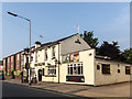
1
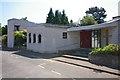
Resurrection Lutheran Church
The church is part of the Westfield House site, but is accessed from Westfield Lane.
Image: © Ben Harris
Taken: 8 Jun 2008
0.02 miles
6
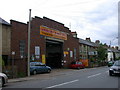
Arbury Fast-Fit
This motor maintenance works was once a corn merchant's store.
Image: © Keith Edkins
Taken: 13 Jun 2008
0.04 miles
7
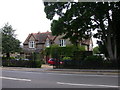
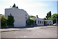
Westfield House
Central Office of the Evangelical Lutheran Church of England
Image: © Keith Edkins
Taken: 20 Jun 2008
0.04 miles
9
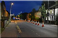
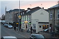
Histon Rd
Long term roadworks on this road are making it one way at present.
Image: © N Chadwick
Taken: 3 Oct 2020
0.04 miles
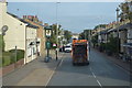
10
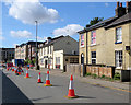
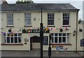
Histon Road: roadworks and The Grapes
Near the Huntingdon Road end of Histon Road.
Image: © John Sutton
Taken: 2 Aug 2020
0.04 miles