IMAGES TAKEN NEAR TO
Blanford Walk, CAMBRIDGE, CB4 3NQ
Introduction
This page details the photographs taken nearby to Blanford Walk, CB4 3NQ by members of the Geograph project.
The Geograph project started in 2005 with the aim of publishing, organising and preserving representative images for every square kilometre of Great Britain, Ireland and the Isle of Man.

There are currently over 7.5m images from over14,400 individuals and you can help contribute to the project by visiting https://www.geograph.org.uk
Image Map
Images are licensed for reuse under creativecommons.org/licenses/by-sa/2.0
Notes
- Clicking on the map will re-center to the selected point.
- The higher the marker number, the further away the image location is from the centre of the postcode.
Image Listing (72 Images Found)
Images are licensed for reuse under creativecommons.org/licenses/by-sa/2.0
Image
Details
Distance
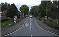
1
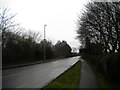
North end of Histon Road, Arbury
Not far into the distance, Histon Road becomes Cambridge Road as it heads out of the city.
Image: © Richard Vince
Taken: 3 Feb 2018
0.05 miles
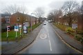
2

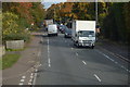
Brownlow Road, Arbury
Seen from Histon Road.
Image: © Richard Vince
Taken: 3 Feb 2018
0.05 miles
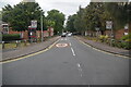
3
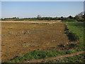
NIAB (National Institute of Agricultural Botany) site
From the end of Brownlow Road. Nothing much has happened for a couple of years, but houses will appear at some point.
Image: © Hugh Venables
Taken: 15 Apr 2015
0.06 miles
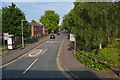
5
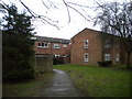
Footpath off Histon Road, Arbury
Providing pedestrian access to a few blocks of low rise flats.
Image: © Richard Vince
Taken: 3 Feb 2018
0.06 miles