IMAGES TAKEN NEAR TO
Victoria Road, CAMBRIDGE, CB4 3LG
Introduction
This page details the photographs taken nearby to Victoria Road, CB4 3LG by members of the Geograph project.
The Geograph project started in 2005 with the aim of publishing, organising and preserving representative images for every square kilometre of Great Britain, Ireland and the Isle of Man.

There are currently over 7.5m images from over14,400 individuals and you can help contribute to the project by visiting https://www.geograph.org.uk
Image Map (Loading...)


Getting Data...Please wait
Leaflet Map data © OpenStreetMap
Images are licensed for reuse under creativecommons.org/licenses/by-sa/2.0
Notes
- Clicking on the map will re-center to the selected point.
- The higher the marker number, the further away the image location is from the centre of the postcode.
Image Listing (512 Images Found)
Images are licensed for reuse under creativecommons.org/licenses/by-sa/2.0
Image
Details
Distance
2
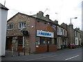
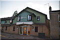
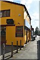
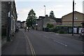
Meghna restaurant and takeaway, Victoria Road
This used to be The Blackamoor's Head pub, a name it retained well into the age when it might be thought inappropriate. For the last few years it has been the Backstreet Brasserie; it now provides "Exotic Indian and Bangladeshi Cuisine".
Image: © Keith Edkins
Taken: 20 Jun 2008
0.01 miles
10
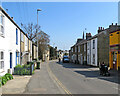
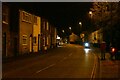
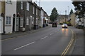
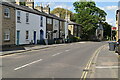
Down Victoria Road
One of the main roads in the Victorian inner suburbs north of the River Cam. St Luke's Church spire shows above the roofs on the right.
Image: © John Sutton
Taken: 19 Apr 2021
0.02 miles