IMAGES TAKEN NEAR TO
Northfields Avenue, CAMBRIDGE, CB4 2LF
Introduction
This page details the photographs taken nearby to Northfields Avenue, CB4 2LF by members of the Geograph project.
The Geograph project started in 2005 with the aim of publishing, organising and preserving representative images for every square kilometre of Great Britain, Ireland and the Isle of Man.

There are currently over 7.5m images from over14,400 individuals and you can help contribute to the project by visiting https://www.geograph.org.uk
Image Map
Images are licensed for reuse under creativecommons.org/licenses/by-sa/2.0
Notes
- Clicking on the map will re-center to the selected point.
- The higher the marker number, the further away the image location is from the centre of the postcode.
Image Listing (91 Images Found)
Images are licensed for reuse under creativecommons.org/licenses/by-sa/2.0
Image
Details
Distance
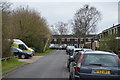
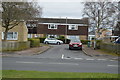
1
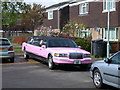
Pink stretch limo
Lucky to find a parking space the right length! As far as I can work out, it is an extended 1995 Ford Lincoln Town Car.
Image: © Keith Edkins
Taken: 23 Apr 2008
0.02 miles
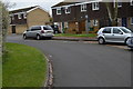
4
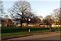
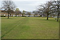
Open space and bus stop
Campkin Road near Arbury Community Centre.
Image: © Alan Murray-Rust
Taken: 23 Dec 2019
0.05 miles