IMAGES TAKEN NEAR TO
Campkin Road, CAMBRIDGE, CB4 2LE
Introduction
This page details the photographs taken nearby to Campkin Road, CB4 2LE by members of the Geograph project.
The Geograph project started in 2005 with the aim of publishing, organising and preserving representative images for every square kilometre of Great Britain, Ireland and the Isle of Man.

There are currently over 7.5m images from over14,400 individuals and you can help contribute to the project by visiting https://www.geograph.org.uk
Image Map
Images are licensed for reuse under creativecommons.org/licenses/by-sa/2.0
Notes
- Clicking on the map will re-center to the selected point.
- The higher the marker number, the further away the image location is from the centre of the postcode.
Image Listing (89 Images Found)
Images are licensed for reuse under creativecommons.org/licenses/by-sa/2.0
Image
Details
Distance
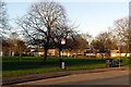
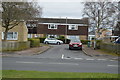
1
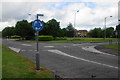
Mini-roundabout on Campkin Road
The junction with Northfields Avenue on the edge of the Kings Hedges estate.
Image: © Bill Boaden
Taken: 25 May 2014
0.03 miles
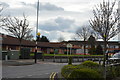
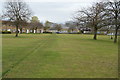
2
Open space and bus stop
Campkin Road near Arbury Community Centre.
Image: © Alan Murray-Rust
Taken: 23 Dec 2019
0.05 miles
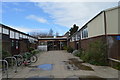
5
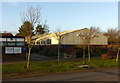
Arbury Community Centre
Purpose built in industrial style.
Image: © Alan Murray-Rust
Taken: 23 Dec 2019
0.07 miles
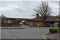
6

Arbury Community Centre
Apart from normal community activities like zumba classes, it also hosts Arbury Community Church.
Image: © Bill Boaden
Taken: 25 May 2014
0.07 miles