IMAGES TAKEN NEAR TO
Metcalfe Road, CAMBRIDGE, CB4 2DD
Introduction
This page details the photographs taken nearby to Metcalfe Road, CB4 2DD by members of the Geograph project.
The Geograph project started in 2005 with the aim of publishing, organising and preserving representative images for every square kilometre of Great Britain, Ireland and the Isle of Man.

There are currently over 7.5m images from over14,400 individuals and you can help contribute to the project by visiting https://www.geograph.org.uk
Image Map
Images are licensed for reuse under creativecommons.org/licenses/by-sa/2.0
Notes
- Clicking on the map will re-center to the selected point.
- The higher the marker number, the further away the image location is from the centre of the postcode.
Image Listing (52 Images Found)
Images are licensed for reuse under creativecommons.org/licenses/by-sa/2.0
Image
Details
Distance
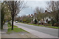
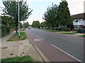
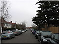
1
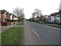
Gilbert Road
A few years ago parking was banned on this road, making it a very pleasant road for cycling.
Image: © Hugh Venables
Taken: 2 Mar 2013
0.12 miles
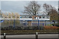
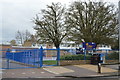
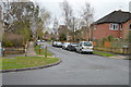
3
Courtney Way, New Chesterton, Cambridge
The entrance to Castle School is ahead.
Image: © David Purchase
Taken: 14 Mar 2012
0.12 miles
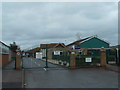
4
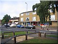
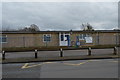
Local shop, South Arbury, Cambridge
The local shop and Carlton Arms pub in Carlton Way, Arbury, near the junction with Metcalfe Road; streetworks with paving and fencing have enhanced the area.
Image: © Rodney Burton
Taken: 12 Sep 2005
0.12 miles