IMAGES TAKEN NEAR TO
Ashfield Road, CAMBRIDGE, CB4 1RZ
Introduction
This page details the photographs taken nearby to Ashfield Road, CB4 1RZ by members of the Geograph project.
The Geograph project started in 2005 with the aim of publishing, organising and preserving representative images for every square kilometre of Great Britain, Ireland and the Isle of Man.

There are currently over 7.5m images from over14,400 individuals and you can help contribute to the project by visiting https://www.geograph.org.uk
Image Map (Loading...)


Getting Data...Please wait
Leaflet Map data © OpenStreetMap
Images are licensed for reuse under creativecommons.org/licenses/by-sa/2.0
Notes
- Clicking on the map will re-center to the selected point.
- The higher the marker number, the further away the image location is from the centre of the postcode.
Image Listing (189 Images Found)
Images are licensed for reuse under creativecommons.org/licenses/by-sa/2.0
Image
Details
Distance
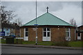
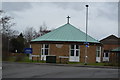
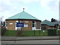
3
Chesterton Methodist Church
A new smaller octagonal building, a few hundred metres out of town compared to the original site (now Chesterton Working Men's Club).
Image: © Colin Bell
Taken: 2 Apr 2008
0.04 miles
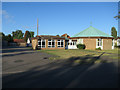
9
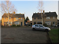
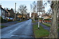
Eastfield
There are plans to demolish these houses and replace them with higher density affordable housing.
Image: © Hugh Venables
Taken: 20 Jan 2016
0.05 miles
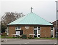
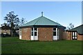
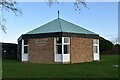
10
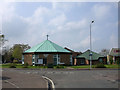
Chesterton Methodist Church, Scotland Road
1950s Octagonal Building on the junction with Green End Road
Image: © Keith Edkins
Taken: 23 Apr 2008
0.05 miles