IMAGES TAKEN NEAR TO
Union Lane, CAMBRIDGE, CB4 1PR
Introduction
This page details the photographs taken nearby to Union Lane, CB4 1PR by members of the Geograph project.
The Geograph project started in 2005 with the aim of publishing, organising and preserving representative images for every square kilometre of Great Britain, Ireland and the Isle of Man.

There are currently over 7.5m images from over14,400 individuals and you can help contribute to the project by visiting https://www.geograph.org.uk
Image Map (Loading...)


Getting Data...Please wait
Leaflet Map data © OpenStreetMap
Images are licensed for reuse under creativecommons.org/licenses/by-sa/2.0
Notes
- Clicking on the map will re-center to the selected point.
- The higher the marker number, the further away the image location is from the centre of the postcode.
Image Listing (288 Images Found)
Images are licensed for reuse under creativecommons.org/licenses/by-sa/2.0
Image
Details
Distance
3
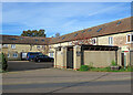
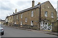
Chesterton: The Maltings, High Street
A former malthouse, now in residential use. A sack hoist, on the wall above the blue van, is a reminder of the building's origins.
Image: © John Sutton
Taken: 28 Oct 2022
0.03 miles
6
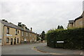
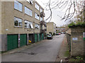
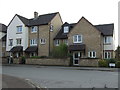
Scotland Road at the junction of Union Lane
Image: © David Howard
Taken: 12 Sep 2021
0.04 miles
7
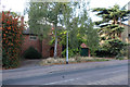
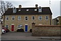
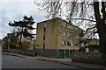
House on Chesterton High Street
With plans submitted for demolition.
Image: © Hugh Venables
Taken: 6 Aug 2020
0.04 miles