IMAGES TAKEN NEAR TO
Manhattan Drive, CAMBRIDGE, CB4 1HL
Introduction
This page details the photographs taken nearby to Manhattan Drive, CB4 1HL by members of the Geograph project.
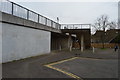
The Geograph project started in 2005 with the aim of publishing, organising and preserving representative images for every square kilometre of Great Britain, Ireland and the Isle of Man.

There are currently over 7.5m images from over14,400 individuals and you can help contribute to the project by visiting https://www.geograph.org.uk
Image Map (Loading...)


Getting Data...Please wait
Leaflet Map data © OpenStreetMap
Images are licensed for reuse under creativecommons.org/licenses/by-sa/2.0
Notes
- Clicking on the map will re-center to the selected point.
- The higher the marker number, the further away the image location is from the centre of the postcode.
Image Listing (637 Images Found)
Images are licensed for reuse under creativecommons.org/licenses/by-sa/2.0
Image
Details
Distance
1
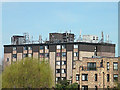
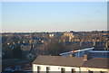
Urban forest
The roof of Mayflower House has good visibility over the Chesterton area and is therefore a popular location for radio aerials. Planning permissions for the site indicate they belong to Hutchinson, Vodafone and Orange.
Image: © Keith Edkins
Taken: 22 Mar 2009
0.02 miles
4
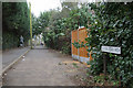
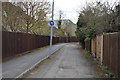
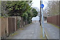
Cutter Ferry Path, Chesterton
Part of a useful pedestrian link from the Chesterton area which manages to avoid main roads.
Image: © Alan Murray-Rust
Taken: 27 Dec 2006
0.04 miles
7
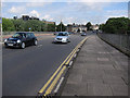
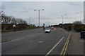
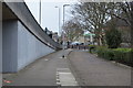
Elizabeth Way
Looking away from the bridge over the River Cam. A cycle route joins the road on the uphill stretch so the dashed lines extend most of the way up the incline. Unfortunately they are inside the double yellow lines for much of this, rendering it all a bit pointless.
Image: © Hugh Venables
Taken: 7 Jul 2012
0.06 miles