IMAGES TAKEN NEAR TO
St. Andrews Road, CAMBRIDGE, CB4 1DL
Introduction
This page details the photographs taken nearby to St. Andrews Road, CB4 1DL by members of the Geograph project.
The Geograph project started in 2005 with the aim of publishing, organising and preserving representative images for every square kilometre of Great Britain, Ireland and the Isle of Man.

There are currently over 7.5m images from over14,400 individuals and you can help contribute to the project by visiting https://www.geograph.org.uk
Image Map
Images are licensed for reuse under creativecommons.org/licenses/by-sa/2.0
Notes
- Clicking on the map will re-center to the selected point.
- The higher the marker number, the further away the image location is from the centre of the postcode.
Image Listing (727 Images Found)
Images are licensed for reuse under creativecommons.org/licenses/by-sa/2.0
Image
Details
Distance
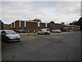
2
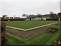
Chesterton Bowls Club
Bowls lawn, with indoor facilities behind.
Image: © Hugh Venables
Taken: 21 Mar 2015
0.05 miles
4
26th Cambridge Scout hut, Logan's Way
In its occasional role as a polling station, in this case for the May 2010 general election.
Image: © Hugh Venables
Taken: 6 May 2010
0.05 miles
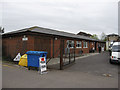
6
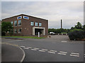
Sepura headquarters, Cambridge
On St Andrew's Road, Chesterton.
Image: © Hugh Venables
Taken: 8 Jun 2012
0.06 miles
9
Chesterton Bowls Club
Indoor and outdoor facilities.
Image: © Hugh Venables
Taken: 8 Jun 2012
0.07 miles
10
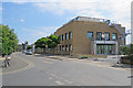
The former Pye factory renewed
The former Pye factory is being renovated as offices. Image] shows the work in February 2017.
Image: © John Sutton
Taken: 9 Jul 2017
0.08 miles